The Road Back To Health
As mentioned in a previous post, on 1st May 2022 I injured my knee and the subsequent healing of that injury brought virtually all my physical activity to a screeching halt. From the activity when the injury occurred through to the 27th of June I didn’t do any exercise. As a result I gained about 7kg, loosing a lot of muscle mass and gaining an undesirable amount of body fat, especially around my abdomen.
On 27th June, I did my first exercise since the injury, a 1km walk. By the end of that week I had done 11km. Not a bad effort for the first week of walking exercise since the injury. The injured knee ached a bit during and after the walk, but not so much that I felt the need to stop walking. The following week I almost doubled the distance walked to 19km, and the week after that I walked 33km. Apart from occasional ache around the injury, everything seemed ok. For the last week of July I walked more than 35km, and for the month of July I walked more than 125km, something I was somewhat surprised about but also found encouraging.
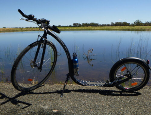
On the 22nd of July, I did my first Kickbike ride since the injury, a 7.5km ride, and 18km of kickbiking for that week, a far cry from what level of Kickbiking activity I was doing pre-injury but it was a start.
As a result of the walking I was doing, my Rundownunder challenge kms started to accumulate again and by the end of July I had reached the next waypoint in that challenge.
31st July 2022 – Barkly Homestead
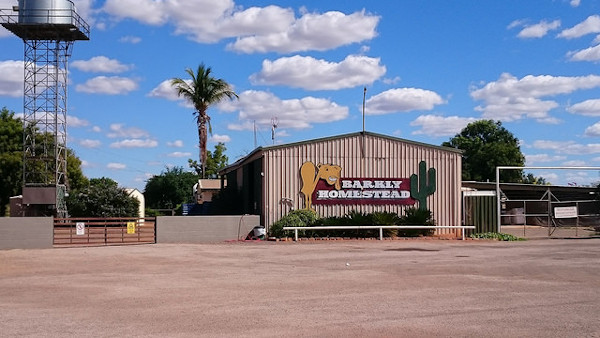
“Barkly Homestead is a remote homestead situated on the Barkly Tablelands, it is located between the Queensland Border Town of Camooweal and the Northern Territory town of Tennant Creek. The homestead provides, Fuel, Meals, Snacks, Camping, Motel, Cabin, and Powered Caravan Sites to travellers passing along the Barkly Highway. It is the only stop between the Stuart Highway and the border of Queensland.” (from Rundownunder email)
I have now walked over 3500km in the Rundownunder challenge, and have walked 43km this week, and 131km for the month of July.
On 29th August 2022, I passed my brother Malcum in the Rundownunder challenge, who is also doing the challenge. This was the second time I have passed him in the challenge, the first time being 12th April 2022. While I was recovering from my knee injury he passed me, and as my kms per week increased I managed to pass him again!
30th August 2022 – Turnoff to Stuart Highway
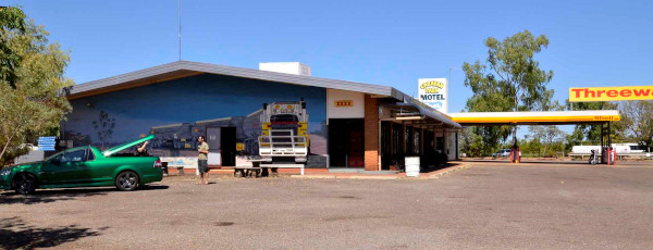
“After travelling west along the Barkly Highway for the past 400km since crossing into the Northern Territory, you would have encountered nothing but vast open space, some airfields, working cattle stations and the odd truck stop or roadhouse.
3,693kms sees you arrive at the Threeways Roadhouse and Tourist Park – situated on the corner of Barkly & Stuart Highways and is a convenient stop for travellers heading North, South or East. The Roadhouse first sold fuel in the 1960’s from 44 gallon drums! In 1972 Shell developed the present site and today the Roadhouse is a family run business with an emphasis on friendly service. The Park features spacious, shady and grassed sites for Caravans and Campers in an outback setting. Enjoy a swim in the sparkling pool or relax with a cold beer or wine at the bar. Cook your own meal on our free BBQ’s or dine at our restaurant and sample mouth-watering specials from our kitchen. Stay for a couple of days and visit some of the local points of interest – Mary Ann Dam, Devils Pebbles and so much more. Turn right from here and head towards the “Top End” of Australia.”
4th October 2022 – Lake Woods
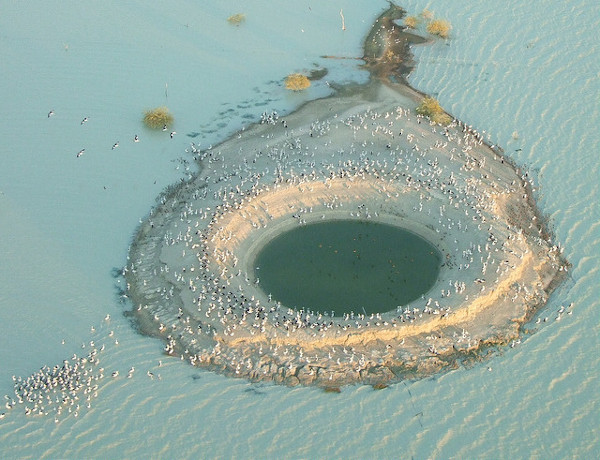
“Welcome to Lake Woods – an ephemeral freshwater lake in the Northern Territory of Australia. It is the largest, temporary freshwater lake in the Northern Territory and can grow in size during the wet season to cover around 1,000 square kilometres. It lies on Newcastle Creek close to the small town of Elliott on the Stuart Highway, about halfway between Darwin and Alice Springs. It is important as a breeding site for waterbirds.
Unfortunately, only a small area of the system is protected. Grazing and inconsiderate tourist use threatens this stunning area. It is considered a site of conservation significance.”
By 20th October I had completed 4000km of the challenge.
Between Birdum and Katherine, the Rundownunder challenge route is somewhat parallel to the former North Australian Railway (NAR) route. The NAR was a 3’6″ gauge railway, that operated between Birdum (at it’s longest length) and Darwin between 1887 and 1977, and was nicknamed by some as “the line that led to nowhere”.
30th October 2022 – Daly Waters
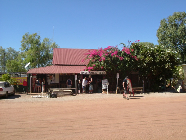
“Welcome to Daly Waters…..home of the famous Daly Waters Pub. The main attractions for tourists is the famous pub, which is decorated throughout with banknotes and other memorabilia left by visitors from every corner of the globe. The historic pub was licensed in 1938 to service passengers and crew from the nearby airfield. A sign at the door of the pub advises that no dogs are allowed, so the owner has a pet miniature pig which is allowed.
The name Daly Waters was given to a series of natural springs by John McDouall Stuart during his third attempt to cross Australia from south to north, in 1861-2. Stuart named the springs after the new Governor of South Australia, Sir Dominick Daly.
Stuart’s first attempt, in 1860, had reached Tennant Creek. The second, in early 1861, pushed further north but again Stuart turned back. The third journey left Adelaide in October 1861 and reached Daly Waters on 28 May. The party had been pushing through difficult lancewood scrub and harsh terrain at a little over a kilometre a day. This journey was successful, reaching the north coast near modern Darwin on 24 July 1862. Stuart’s Tree has an ‘S’ carved into it by Stuart during his journey.
The Overland Telegraph Line reached Daly Waters from the north in June 1872 and for two months a ‘pony express’ carried messages the 421 km to Tennant Creek via Renner Springs, Northern Territory. Daly Waters Airfield was a centre for the London to Sydney air race of 1926, a refuelling stop for early Qantas flights to Singapore, a World War II Airforce base and more recently an operational base for joint military manoeuvres. Although the aerodrome was closed to commercial traffic in 1965 the original Qantas hangar still stands, housing exhibits of photographs and equipment from the area’s aviation past.
The traditional owners of the area became the fourth Indigenous group in the Northern Territory to gain native title over both the town site and ten surrounding pastoral leases covering an area of 30,000 square kilometres. The Australian Federal Court had a special ceremonial sitting on nearby Newcastle Waters Station to commemorate the occasion.”
15th November 2022 – Larrimah
On the North Australia Railway (NAR), at the time of World War II, Larrimah (501km from Darwin) was a level area and had the advantage of being the place where the main road from the south first met the railway. Because of this, Larrimah became the transfer sites for goods trucked to and from Alice Springs along the Stuart Highway. A new marshalling yard was built on the western side of the NAR mainline with a loading ramp and 5 tonne gantry crane, 5 tonne jib crane, goods shed, Army Service Corps transit shed, refrigeration store, and over 400 metres of loop siding.
25th November 2022 – Mataranka
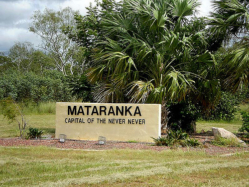
“Mataranka is a community of about 400, in the Top End region of Australia’s Northern Territory. The town is located about 420 km southeast of the territorial capital, Darwin. The town is located near Roper River and Mataranka Hot Springs. This area is the setting for Jeannie Gunn’s autobiographical account of the year 1902, We of the Never Never. The homestead, which she shared with her husband, Aeneas Gunn, until his death, has been reconstructed near to the hot springs. The Mataranka Station is part of the Katherine Rural College of Charles Darwin University.
Mataranka Thermal Pool is a great place to unwind. The warm, crystalline waters of the natural pool is said to have the power to soothe aches and pains after a long day on the road. The water is spring fed, bubbling up at a fairly constant temperature of 34 degrees Celsius. The surrounding paperbark and palm forest filters the sun and leaves soft, dappled light playing on the water’s surface. The area around the pool is a natural breeding ground for the little red flying fox. The breeding season is usually from November to May, but often extends into the drier months. The Mataranka Thermal Pool may be inaccessible at times due to flooding between the months of November through to April.
The Australian Army set up No. 42 Australian Camp Hospital near Mataranka. The 10th Australian Advanced Ordnance workshops camped in buildings made from paper bark trees and serviced wrecked and damaged vehicles. An ammunition depot was also in the locality. These depots were served by railway sidings off the North Australia Railway (NAR) main line.
The NAR railway station at Mataranka (426km from Darwin) was assured of a good supply of water from the nearby Roper River, which was a very important commodity for any railway in the days of steam engines. Apart from the Army facilities mentioned above, a 300 metre crossing loop, a railway ‘triangle’, and cattle yards were located here.” (From Rundownunder email and “The Line That Led to Nowhere” book).
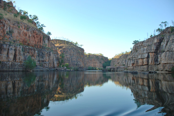
12th December 2022 – Katherine
“Katherine is home to the infamous Katherine Ultra Challenge – a one-day multisport event encompassing six different legs covering 100km’s around the Katherine region.
Speaking of an Ultra Challenge – it’s been 4,306km since you left Canberra to start YOUR Run Down Under journey. You have passed through 33 towns; you have visited 4 states of Australia; you have learnt a lot more about this amazing country, AND…………you have become fitter & healthier as a result!
Often called the ‘Crossroads of the North’ because of its location, Katherine is the fourth largest town in the Northern Territory and is located 312 km south-east of Darwin on the Katherine River. With a population of over 10,000 people Katherine is a modern thriving regional centre that offers a wide range of services to communities from the Western Australian border to the Gulf of Carpentaria on the Queensland border.
The Municipality of Katherine covers an area of 7,421 square kilometres and is located on the beautiful Katherine River, offering a range of swimming, fishing and recreational parks. The Katherine Region is 336,674 square kilometres; almost the size of Victoria, and the Australian Height Datum has listed the main street of Katherine (at the intersection of Warburton Street and Katherine Terrace) as being 104.57 meters above sea level. The total population of the region is just over 24,000 people of which 60% identify as Indigenous.
The Katherine Town Council is dedicated to offering quality services to the people of Katherine. The Council works actively with the community to create a vibrant, safe, happy place that offers attractive business, social and cultural opportunities for everyone. The Katherine Town Council operates the Katherine Visitor Information Centre. We have in place an online booking centre which allows you to make all of your tour and accommodation bookings online, www.visitkatherine.com.au.”
The North Australia Railway (NAR), in 1943, had 15 sidings branching of from a spur servicing the Katherine Loco Depot (322.5km from Darwin). The Army file described the workshops in 1944 as “fully equipped” but the word “fully” had been deleted and “moderately well” written over in ink. The Loco Depot consisted of six distinctive gabled roofed workshops, and was still standing some years after closure of the line being used as a works depot for the Department of Construction. At Katherine (323.5km from Darwin) the high level railway bridge across the river was also used by road transport in the wet season, with trains having right of way, due to the low level bridge being covered by up to 20 metres of water. A high level road bridge was not opened into 1976. In the Katherine area the Army had established a hospital and meatworks, as well as supply dumps. On the opposite side of the line from the loco depot a 2.5km siding was added which ran parallel to what was then the road to Darwin, to service the Katherine Field Supply Depot. A few kms further south (at 325km from Darwin) was a Defence Siding which had two filling points for motor transport fuel, with two 45,461 litre petrol tanks 100 metres back from the track.
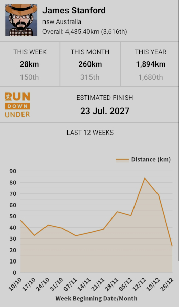
It was my goal for the year to reach Katherine in the Rundownunder challenge, so not only did I complete the Daly Water – Katherine Rundowunder section, I also completed my year’s goal and about 3 weeks early, and inspite of doing no exercise for nearly 3 months after my knee injury on 1st May. The next waypoint was the Gregory National Park, 179km from Katherine. To reach there by the end of 2022 I would have to walk an average of 9.2km for the next 19 days after I reached Katherine. While this is certainly not impossible given my previous walking history, it would be a bit of a stretch. So would I make it?
I certainly gave it a jolly good try.
- 5th – 11th December: 50.4km walked.
- 12th – 18th December: 83.8km walked. This is my personal record for kms walked in a week, at least since I started the Rundownunder challenge in 2022, and probably a lifetime record!
- 19th – 25th December: 68.7km walked.
- 26th – 31st December: 28km walked.
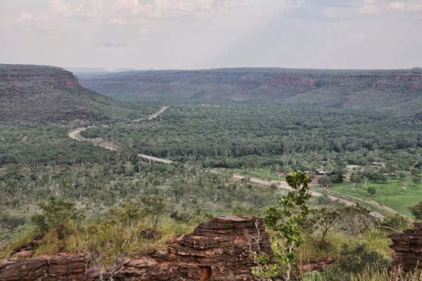
28th December 2022: Gregory National Park
I made it, with a few days to spare, after walking 260km in December, and 1894km in the whole of 2022.
“You have been heading South-West on the Victoria Highway since leaving Katherine, and have reached the 4,485km mark on YOUR journey as you arrive at Judbarra / Gregory National Park.
Marked walking tracks have been developed within the Park. Before embarking on an extended bushwalk, visitors must first obtain a permit from a Ranger station. … The park covers an area of around 13,000 square km in the transition zone between tropical and semi-arid regions of the Northern Territory. The Park features spectacular range and gorge scenery and significant traces of Aboriginal culture, European exploration and pastoral history. The park includes traditional lands of several Indigenous Australian groups, including Ngarinyman, Karrangpurru, Malngin, Wardaman, Ngaliwurru, Nungali, Bilinara, Gurindji and Jaminjung, and spans the boundary between two major Australian language families, Pama Nyungan and Non-Pama-Nyungan (Northern).
The rock shelters and caves in Judbarra/Gregory contain an extensive amount of rock art, variously created by painting, stencilling, drawing, printing, and “pecking and pounding”. The human figure is the most common motif; the park is “one of the most prolific sites in Australia” for composite engraved and painted human figures. The rock art of the Judbarra region is considered to represent a distinct art province.”
And that finishes the year 2022, as far as walking is concerned. At the end of year my weight was down to 79kg from a high of 85kg when I started exercising again, a loss of 6kg. Just a few more to go and I’m back to what I consider my ‘ideal weight’ (77kg).
You May Also Like
2 Comments
Sandra Rae Glew
Well done James – you must have lost the weight you gained when your knee was injured doing the walking you have done after your injury. You passed Malcum twice – he couldn’t have been doing as much walking as you, and he didn’t have an injury. What have you planned for 2023?
Hope you are all well and best wishes for a healthy, happy and prosporus 2023. Andrea & I are in our new home and still unpacking and trying to find places for everything we bought with us from a much bigger house. It is nice here at Koroit – quiet, more so than at Berringa. Our street is a no thru street so we don’t get much traffic going past. We have had a nice cool breeze nearly every day since we moved here – yesterday was the hottest day so far 37deg, don’t need anymore of that heat.
Bye for now
Luv Sandy
Mum
Well done, James. I enjoy the Geography lesson and pictures.
Luv, Mum