North Coast 500 Virtual Challenge
The North Coast 500 is a touring route 516 miles (approximately 825km) long around the northern coasts of Scotland. The official length is the 516 miles. The Conqueror Virtual Challenges also has a challenge called the North Coast 500, which follows the official route fairly closely, but is only 500 miles (805km) long.
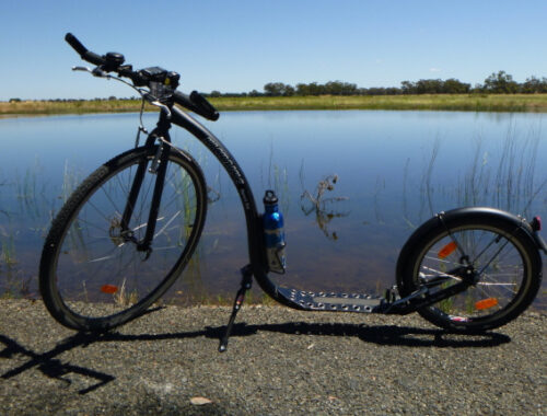
My family on mum’s side has Scottish ancestory, and in our family there is more than a little interested in Scotland and it’s history. So the Conqueror Challenges North Coast 500 seemed like something I could immerse myself in. I had purchased the challenge at the start of 2022 as a bundle, and had planned to use my Kickbike to do the distance of the challenge starting after the heat of the 2022 / 2023 summer. But after the knee injury in May, and subsequent recovery, I decided to start the challenge much earlier and actually started it on 31st July 2022, allowing myself 210 days to complete it to allow for possible requirements to rest my healing knee, potentially bad weather over Winter and Spring (which we actually had, with an La Nina event), and the heat of Summer, possibly keeping the kms I could ride each week low. I also set a goal of up to 1/3 of the kms ridden for this challenge being done on my K-Rock 20″ Foldable Bike, as my knee and left heel were still experiencing some soreness and riding a more standard bike helped keep the kms up while giving my knee and left heel a bit of time to heal between Kickbike rides.
“The northwest corner of mainland Scotland is a landscape of wild and rugged coastline, scattered sandy beaches and quaint little hamlets and villages. The northeast coastline has a fine collection of impressive castles such as Dunrobin Castle and Castle of Mey along with castle ruins and towers that fires up the imagination of medieval times. The North Coast 500 (NC500) is a circular route travelling through the counties of Inverness-shire, Ross and Cromarty, Sutherland and Caithness. The route was launched in 2015 in an effort to connect the remote coastal villages and showcase the Highlands’ expansive moors, deep lochs and craggy peaks.” (from postcard email for Inverness)
The write ups for each postcard are from The Conqueror Challenges postcard emails, and are in the 1st person, as a kind of travelogue as if I had actually done the journey.
31st July 2022 – Inverness
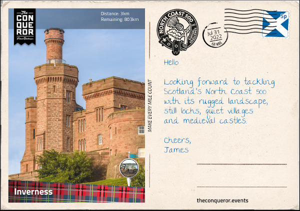
“The route begins in Inverness at Inverness Castle. The city is widely regarded as the capital of the Highlands and is generally the starting base for exploring the region. Each year in September, bagpipe players convene for a solo competition and the chance to win the Gold Medal, a prestigious award that qualifies the winner to participate in other restricted competitions.
Inverness Castle was built in 1835 on a previous 11th century castle site. Designed by three architects with each one focusing on different sections, the castle was built out of red sandstone in a castellated style. It sits on a cliff overlooking River Ness with views of Ness Bridge and Inverness Cathedral.
Outside the Castle’s main entrance stands the statue of Flora Macdonald, who is known to have helped Bonnie Prince Charlie escape Scotland in 1746 after he lost the Battle of Culloden. She helped him with passage on a boat to the Isle of Skye by dressing him as a maid named Betty Burke. Although she was captured and imprisoned for her involvement, Flora was released a year later. She emigrated to North Carolina, however, she lost her estate and possessions during the American Revolutionary War when her husband took up arms supporting the British army, forcing her to return to Scotland, where she lived out the rest of her life.
The River Ness runs through the centre of Inverness and spills into Beauly Firth (an inlet). At 6mi (10km) long its origin is Loch Ness (lake) which is located further south of Inverness. At 23mi (37km) long and 755ft (230m) at its deepest point, Loch Ness is famous for its mythical creature the Loch Ness Monster endearingly known as Nessie.
Legend has it that Nessie was first sighted by St Columba in the 6th century. By the 1870s new sightings were reported describing Nessie either as a salamander lookalike or resembling a plesiosaur. When unusual photos appeared in the 1930s along with further sightings, the story of Nessie took a real hold and perpetuated throughout the decades till today. Mythical or not we have to give Nessie credit for her incredibly long lifeline. At nearly 1,500 years old, her agility in appearing and swiftly disappearing must be commended. With plenty of room to swim in the loch, it looks like Nessie enjoys the game of hide and seek as no one has been able to capture her or even get a clear photo of her.”
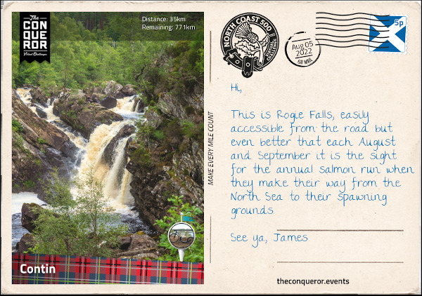
5th August 2022 – Contin
“Just outside of Inverness is the Achnagairn Castle. Built around 1812, the castle was the setting for parts of the Outlander TV series. An elegant whitewash three storey building with French windows, the castle is more of a mansion with two bell-shaped towers overlooking a formal garden. A ballroom was added in 1912. The then-owners’ daughter was turning 21 and had nowhere to celebrate her birthday. The parents built her the ballroom clad in wood panels and sandstone bricks with vaulted ceilings, chandeliers and a massive fireplace. During WWII the ballroom served as a hospital filled with beds. Sadly over the latter decades of the 20th century the building fell into disrepair until it was rescued, restored to its former glory and converted into a boutique luxury hotel.
On the way to Contin I passed through the towns of Beauly and Muir of Ord. Beauly’s name was derived from Mary, Queen of Scots exclamation “Ç’est un beau lieu” meaning it’s a beautiful place when she visited the area in 1564. Located on the bend of Beauly River is the Beauly Priory where Queen Mary made her observation from. The priory was built in the 13th century and existed for the next 300 years until the Reformation brought it to an end and the priory was abandoned. Only the walls remain with the roof having long gone but the grounds continue to maintain tombstones from the 1400s along with mature trees and an ancient elm tree.
Less than 3mi (5km) north of Beauly is Muir of Ord, a small village that once was known as Tarradale. It is the birthplace of geologist Roderick Murchison (b.1792) who established the Silurian System by grouping together a series of geologic formations from a time period between 443-419 million years ago.
Just northwest of the village is the Glen Ord Distillery which prior to becoming a legal establishment in 1838 was an illegal whiskey distillery. The operations grew quickly and as such so did the population in the village giving the economy a boost. Within 50 years the distillery was producing 80,000 gallons (303,000L) per year with production exported as far afield as Singapore and South Africa. Although the distillery has changed hands several times it continues to operate today producing single malts such as The Singleton.
Contin is a tiny village of around 670 residents located near Black Water River. Just north of the village, off the main road, is a short hike through woodland to Rogie Falls that plummets 30ft (9m) into Black Water River. It is a hillside cascade flowing over several layers of large boulders that is best viewed from the nearby suspension bridge.
I finished the day with a quick side trip to the spa town of Strathpeffer. When the spring waters were discovered to have healing properties back in the 1800s, local landowners transformed this once sleepy village into a highly coveted spa resort. Several Victorian properties cropped up in quick succession opening their doors to wealthy visitors seeking fresh air, restorative springs and a round of golf. After WWI the resort town went into decline until recent times when a local association went about restoring various important buildings and re-igniting the village as a spa resort.
One of the town’s highlights is the ornate railway station. Closed in 1946, by the mid-1950s it was in a terrible state with the tracks long gone and the surrounding vegetation scraggly and overgrown. Restored to its former glory in the early 1990s, the station is now home to the Highland Museum of Childhood, a café and gift stores. This is a good place to take a load off and indulge in a pot of tea and scones, jam and cream.”
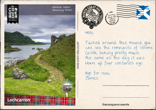
18th August 2022 – Lochcarron
“Travelling passed fishing lochs, reservoirs and small villages I arrived at the road junction of Achnasheen that was built by Thomas Telford. A civil engineer, architect and stonemason, Thomas was an exceptional designer. His reputation was of such standing that he was nicknamed “The Colossus of Roads” having been responsible for the design and construction of numerous roads throughout the UK and more importantly for connecting many Highland districts that were previously inaccessible.
Starting as a stonemason in 1771 when he was just 14 years old, over the next 63 years his infrastructure projects included over 1,000 bridges, several canals including the Göta Canal in Sweden and the Caledonian Canal in the Highlands, harbours and numerous churches. Thomas was also an accomplished writer having contributed to the Edinburgh Encyclopaedia and publishing poetry before his rise to fame as an engineer.
Having left an impressive list of completed works throughout the UK and serving as the first President of the Institution of Civil Engineers, Thomas’ legacy is annually recognised via the Telford Medal, a prize awarded each year to authors who have produced exceptional written works that benefit the civil engineering and construction industry.
Having paused for a moment at the junction to absorb the works of Telford, I swung southwest travelling alongside several lochs into Lochcarron. Prior to 1813, it was known as Janetown, a tiny village that tripled in size when a major road coming from Inverness opened up. The village is located alongside Loch Carron, a sea lake that provides excellent opportunities for diving and underwater photography. One of the highlights for a photographer is the seabed of flame shell, a species of small saltwater clam with bright orange tentacles protruding from the edges. Fish such as 15-spined stickleback, named as such due to its 14-17 spikes in front of its dorsal fin, and small-spotted catshark can also be found in the lake.
As a castle enthusiast, I took a sidetrip to the ruins of Strome Castle. Built in the 1400s up on a rocky bluff, the castle was strategically important as it guarded the Strome Narrows at the mouth of Loch Carron. In the hands of the Macdonalds of Glengarry a century later, the castle was often fought over with the neighbouring clan, the Mackenzies. One night in 1602, water was drawn from the well and accidentally deposited in the barrel containing the stock of gunpowder instead of the water barrel, rendering the castle defenceless. Receiving news of this error, the Mackenzies besieged the castle. Negotiations ensued and the Mackenzies agree to provide safe passage to the Macdonalds. Once the Macdonalds left, the Mackenzies blew up the castle. Although very little remains today of the castle the visit is worth it for the views overlooking the lake, the narrows and the deeply rich and green landscape.
This section completes the southern part of the NC500. From Lochcarron I’ll be winding my up the west coast all the way to Durness.”
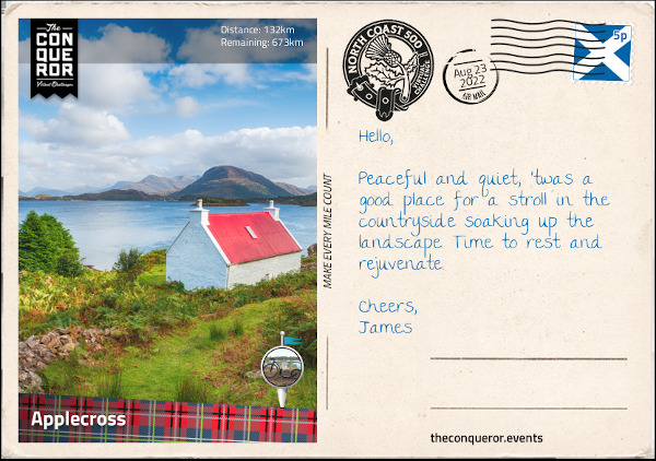
23rd August 2022 – Applecross
“Reaching Tornapress, I took a left turn onto Bealach na Bà, a mountain pass that crosses the Applecross Peninsula. Aside from being incredibly narrow, barely one lane wide, with several hairpin bends the pass very quickly gains elevation. Starting at sea level, the road crossed Russel Burn and tracked along the side of a munro known as Sgurr a’ Chaorachain for a total of 5mi (8km) reaching the top at 2053ft (626m). The gradient on this stretch was nearly 20% making it the steepest ascent on any road in the UK.
The mountain pass was built in 1822 and until the late 20th century it was the only way to access the communities on the peninsula. As its Scottish Gaelic name suggests, Bealach na Bà translates as Pass of the Cattle because the pass was initially used as a drovers’ road to take cattle and sheep to the markets in Inverness.
At its highest point was a lookout with views of the Inner Sound and Loch Carron to the south and the mountain peak of Beinn Bhàn to the north. A dirt trail led to the peak of Sgurr a’ Chaorachain to the right or Beinn Bhàn to the left via a longer trail along the ridge.
From the top the track gradually descends through expanses of moorland all the way into Applecross. A small settlement consisting of a row of houses along the shore it is more commonly referred to as Shore Street or The Street instead of Applecross. Apparently Applecross is not one village but a collection of settlements along the Applecross Bay. Although the other settlements have their own name this row of houses doesn’t seem to and it’s perhaps why it is called Applecross when looking it up on maps. Quite confusing for sure.
Visible across the bay is the long and narrow Isle of Raasay and to the north of Applecross where I planned to park my weary legs was the Applecross Walled Garden. The walled garden was once part of Applecross House, a picturesque white mansion that was built in the 17th century. Changing hands several times over the centuries the garden was abandoned and fell into disrepair. Roll in the 21st century and the garden changed hands once again when it was lovingly restored to its former glory. Evolving over the years the garden now has a café with fresh produce grown on site.”
On 26th August 2022, I reached the 20% completed point of the challenge.
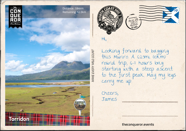
28th August 2022 – Torridon
“Leaving Applecross, for the next 13mi (21km) I travelled along the coast of the peninsula northward bound. Wide open spaces were a constant on this narrow winding road with mountains visible in the distance, the Inner Sound to my left and the Isle of Rona beyond it.
Reaching the settlement of Fearnmore at the northern tip of the peninsula my journey commenced a southeast bound direction passing several small villages alongside Loch Torridon which joined with Loch Shieldaig that joined with Upper Loch Torridon before arriving into the village of Torridon.
Torridon is a great base for any climbing, hiking, mountaineering or wildlife spotting. It is surrounded by mountains and hills with plentiful trails to climb to the top and take in the splendid views in any direction. There are three main ridge climbing mountains: Liathach, Beinn Eighe and Beinn Alligin.
Of the three the easiest to traverse is Beinne Alligin and one I chose to tackle. Located a short distance from the village the mountain has two peaks known as Sgùrr Mhòr and Tom na Gruagaich. Both peaks are over 3,000ft (914m) giving them the status of a Munro, which is a Scottish classification for peaks of aforementioned height that must appear on the Scottish Mountaineering Club official list (there are 282 Munros on the list).
A circular route, the trail starts at the Beinne Alligin carpark near the bridge over the river Abhain Coire Mhic Nobuil. Starting on the west side of the river, the trail heads northwest and soon I reached a deer fence with a stile, a set of steps kind of like a ladder, used to cross the fence. Stepping over I continued up the moor on a somewhat rocky path barely a foot wide until I reached the corrie, a term used in Scotland, that is essentially a round hollow in a hillside (aka a cirque). Stopping for a break I admired the steep and rugged cliff face and turned to look down the trail and the view of Upper Loch Torridon in the distance.
Winding up the corrie, I arrived at a plateau and shortly after at the first peak, Tom na Gruagaich with views of the loch and the Isle of Skye to the south and the ridgewalk to the north. Descending slightly on a steep and rocky path across a saddle and then back up, I started a steep climb to Sgùrr Mhòr, the second peak. Just before reaching it I came across a deep but narrow gash in the cliff face on the southeast side plunging down the mountain. It’s really just a gully but I imagine it like a deep scar. At this point I could either proceed across the Horns of Alligin by scrambling or return the same way I came.
Never to back down on a challenge, I chose to do the scrambling. Descending the ridge I came across the first of the three Horns. Winding my way up over it with a bit of scrambling, the next one was pretty straightforward over the top but the third one I had to get off the ridge and skirt around the horn on a ‘near impossible to find’ extremely narrow path before getting back on the ridge. This is one place where surefootedness was paramount, as a slide down the side of the mountain was not advised.
Having made it this far, I began my descent. Whilst the trail was well marked the descent itself was extremely steep and required plenty of care. I continued until I reached a small footbridge crossing a stream and carried on to a series of waterfalls. The stream joined Abhainn Coire Mhic Nobuil river right where I crossed another footbridge and followed the river on the east bank all the way back to the carpark.”
13th September 2022 – Poolewe
“The road from Torridon to Kinlochewe may be narrow but the vista of mountains on either side is striking. Ambling beside a stream, we part way and rejoin many a times till the stream spills into Loch Clair and then flows out the opposite end as a river all the way to Kinlochewe where we go our own separate ways.
Kinlochewe sits in a valley at the head of the very large Loch Maree and serves as a junction between Torridon and Ullapool where I will be heading further up north. Just slightly to the north of the village is a war memorial for remembering soldiers from World War 1 & 2 particularly two sergeants from the Seaforth Highlanders Regiment who received the Distinguished Conduct Medal, the second highest military decoration at the time behind the Victoria Cross. The medal was awarded for their bravery and gallantry in the field.
Swinging left I headed towards Loch Maree and followed alongside it for its full 13mi (22km) length. At 2.5mi (4km) wide, Loch Maree is the fourth largest freshwater lake in Scotland. The lake consists of five large wooded islands and a staggering 60 smaller ones. The largest is Eilean Sùbhainn located near the top end complete with its own lake in the centre. What’s peculiar though is that northeast of Sùbhainn is a very small densely wooded island, known as Isle Maree, and in the centre of it was a cluster of a dozen or so tombstones. I wondered at its story, who were the people buried here? Well perhaps the most intriguing story is of the Viking prince and his princess who took their own lives following a misunderstanding.
Legend says that the prince left his new bride on the island for a long expedition at sea. It was agreed that should he return and all is well he’d raise a white flag from his barge or if otherwise, a black flag would be shown. The princess would leave her home on a barge as well to greet him on the loch and do the same thing. The idea was to reduce the last moments of suspense on whether all is well or not. As time passed despair overtook the princess, that slowly turned to jealousy and mistrust of her husband’s love for her. So she devised a plan to test him. Upon his return whilst still on his barge, she raised the black flag on her own barge and pretended to be dead. Seeing the black flag, he went into a rage that put fear into his men. When he reached the barge and saw his eternally sleeping bride, he was so stricken with grief that he plunged his dirk into his chest and died. The princess realising her folly and wracked with remorse pulled the dirk from his chest and plunged it into her own. The bodies of the lovestruck pair were buried on the island with their graves bearing two medieval crosses on top that are still there today. A very Romeo and Juliet type of tragedy but it is a common lore that is regularly told in the nearby village of Gairloch.
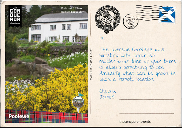
Passing through Gairloch, I travelled onwards to Poolewe aiming for the lovely Inverewe Gardens. It was created in 1862 from extremely barren land by Osgood Mackenzie. The estate was bought for him by his mother and a lodge was built on the property. Unfortunately it burnt down in 1914 and a replacement lodge was built in 1939. By 1952 Osgood’s daughter handed the property into the care of the National Trust of Scotland who have been managing the 50 acre estate since. The gardens have a collection of over 2,500 exotic plants but none are as spectacular as the rhododendrons that are in flower all year long.
The village of Poolewe is located between mountains and the sea. It has the shortest river in Scotland, all of 1mi (1.6km) long which runs through the village connecting Loch Maree to Loch Ewe. On the shore of Loch Ewe is the Poolewe Hotel. Built in 1570 it was originally a coach inn and it seemed like a great place to rest and enjoy a meal of pan fried Scottish salmon with broccoli & garlic sauce, sauteed potatoes and cauliflower.”
On 26th September 2022, I reached the 40% completed point of the challenge.
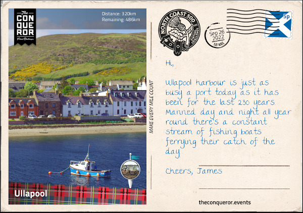
26th September 2022 – Ullapool
“As I headed towards the village of Garve, I nearly missed the waterfall tucked between trees on the side of the road. Curious about where it was coming from a five minute walk further took me to a faint rocky path that led up towards the river and onto a series of falls known as Ardessie Falls. From up here I enjoyed gorgeous views across Little Loch Broom and An Teallach, a mountain to the east of the falls.
An Teallach is a complex mountain with ten peaks over 3,000ft (914m). Whilst they could all be classified as Munros only the highest peak, Bidean a’ Ghlas Thuill at 3,484ft (1,062m) carried that honour until 1981 when it’s nearby Sgùrr Fiona summit was added to the list.
Reaching Garve, I took a hike up to the Sgùrr Fiona and experienced the most splendid panorama of mountainous landscape with Loch na Sealga below and the winding course of two rivers joining together that poured into the lake.
My next stop was the Corrieshalloch National Nature Reserve to visit the Falls of Measach, a 157ft (45m) tall waterfall that crashed into the Droma River below and coursed its way through a narrow gorge all the way into Loch Broom. Following a woodland trail, I arrived at a suspension bridge where the waterfall tumbled over several layers before plunging into the river. Crossing the bridge, I walked a little further up to another platform where I could enjoy the tree-lined gorge, the waterfall in the distance and the suspension bridge above it. Travelling north-westerly again, I reached Loch Broom the sister lake to Little Loch Broom. The two lochs are parallel to each other and divided by a peninsula which contains the mountains of Beinn Ghobhlach and Beinn nam Ban. To the east of Loch Broom is the village of Ullapool.
With a population of 1,500 residents, Ullapool is the largest settlement in the region and serves as an important port for fishing, yachting and ferry transport. The village was founded in 1788 and designed by Thomas Telford expanding the then existing hamlet of 20 households. The village is surrounded by mountains and Ullapool River runs through it.”
9th October 2022 – Drumbeg
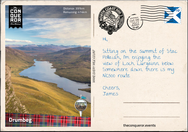
“Bearing north then northwest, I arrived at Stac Pollaidh and its dramatic rocky crest and the adjacent Loch Lurgainn. At only 2008ft (612m), Stac Pollaidh is a popular hiking destination. It has a circular route with a separate path to the northeast for the final ascent to the summit ridge. Whilst this last stretch is a steep climb it is still easily accessible. However, the true summit lies on the western side of the ridge which requires a high level of scrambling experience and a good head for heights due to the several rocky towers that must be climbed to reach the top.
As the Stac stands alone in a relatively flat landscape the views offered are breathtaking. To the north are Inverolly forest, Loch Sionasgaig and the neighbouring peaks of Suilven and Cùl Mὸr, whilst to the south is Loch Lurgainn at the base of the mountain and the Summer Isles in the distance.
The interesting formation of the rocky stacks atop a smooth-sided mountain is a result of weathering during the Ice Age. Known as a nunatak, the summit ridge protruded above the ice sheet giving its rugged head, whilst below as the ice melted and flowed, it smoothed the sides of the mountain.
Carrying on via the usual single track road, I had Loch Lurgainn as a companion until a small land formation separated it from my next companion Loch Bad a’ Ghaill. At Badnagyle I took a right turn and weaved my way into Achmelvich. This settlement via a somewhat difficult single track road, off the main tourist road is worthy of a visit for its Blue Flag beach (awarded to beaches with pristine water) that also carries the Marine Conservation Society status for its marine protection area.
Another curious feature is Europe’s smallest castle locally known as the Hermit’s Castle. It was built by an architect in the 1950s when according to lore he got fed up with the world and wanted to get away from it all. He spent six months building this concrete 3.8mi² (10m²) “castle” that barely stands about 8ft (2.4m) tall by bringing all the material by sea. It’s questionable whether he obtained permission to erect the structure but it seemed that after spending only one weekend in it, he got up and left, abandoning it to the wild of the western highlands. Vandalised in the 1970s when its windows and door were destroyed, the little castle is now sometimes used for shelter, called a bothy in Scotland and provides much amusement to visitors whilst overlooking the Minch (a strait).
Now anyone who likes a good rock formation would be in awe of the 197ft (60m) tall sea stack known as the Old Man of Stoer. … It is popular with rock climbers due to its height and varying levels of difficulty. I think of it as a long-lost cousin of the 12 Apostles on the Great Ocean Road, Australia.
Just past the village of Clashnessie is a big sandy beach in the bay of Clashnessie to while away the day, however, I was much more interested in the short walk upstream to see the 49ft (15m) tall waterfall. Tucked in-between the hills the fall coming from the a small lake above flowed over the rocky wall creating a curtain like appearance, landing on the rocks below and flowing its way into Clashnessie Bay.
Wrapping my day, I made my way into Drumbeg, a small village with a mere population of 100. Before settling in for the night I wondered up to the Drumbeg Viewpoint for the lovely views across Eddrachillis Bay to the north, Loch Drumbeg to the south and Quinag mountain range to the east.
The Eddrachillis Bay is the site of one of the earliest known shipwrecks in Scotland. Following an archaeological survey it is believed that the wreck which consists of three iron cannons, a Delft tile (Danish tile) and remnants of a wooden hull, is of a mid-17th century trading vessel from northern Europe. This medieval wreck however, is not the only one resting on the seabed of the bay. The ex-liner Bermuda had the misfortune of catching fire not once but twice at which point it was beyond repair. Whilst undertow to the scrapyard both tow ropes snapped washing the ship onto rocks. Re-attaching the ropes and moving off the rocks the ropes parted again. This time the ship washed further inshore making it impossible to refloat. She has been left there since 1930 and today serves an occasional diving site.”
17th October 2022 – Durness
“Gosh some of these single track sections are so narrow they could barely be called laneways. With rocky hills to one side and lochs on the other, it makes for some very difficult navigation. It eventually reaches moorland and whilst the track is no wider, the sense of space and views of the lochs and seas in the distance are magnificent.
Taking an east to southeast direction, I arrived at a junction where I took a left turn and passed through Newton, Unapool and over Kylesku Bridge that crossed the Loch Cairnbawn (a sea inlet of Eddrachillis Bay) to the west which splits into two lochs to the east; Loch Gleann Dubh bearing east and Loch Glencoul bearing southeast which then runs into Loch Beag.
Making a stop in the village of Kylesku, I took a boat-trip to Loch Beag so I could see Eas a’ Chual Aluinn, the highest waterfall in the UK. At 658ft (200m) the waterfall has a sheer vertical drop into the glen below. For the adventuring hiker, the waterfall is accessible through boggy ground via a 6mi (10km) in and out route. It crosses several rivers and over steep, rocky and rough terrain to reach the top of the waterfall.
Completing the final stage of the westside of NC500, I travelled through Scourie known for its rocky bay and seaside cemetery, then from Laxford Bridge the route moved inland all the way into Durness.
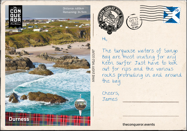
Durness is the most northwesterly village in Scotland and marks the start of the northern route of the NC500. Here I explored Sango Bay with its golden sand and turquoise water surrounded by rocky cliffs. A short distance away was Smoo Cave that was formed by both the sea and a river.
Smoo Cave was at the end of a very narrow and steep-sided inlet that I accessed via a set of stairs from the west side of the cave. At the bottom I crossed the stream via a wooden bridge and followed the path to the first chamber which measured 200ft (61m) long, 130ft (40m) wide and 50ft (15m) high. This section of the cave was carved by the sea gushing through the inlet.
To the west of the first chamber, is the second chamber which was carved by the freshwater river Allt Smoo. Here I could hear the roaring sound of a waterfall, a result of the river dropping through a sinkhole. The sinkhole can also be viewed from above where a small bridge was placed over the river. A trail to the east of the cave leads alongside the inlet at the top giving a spectacular view of the sheer cliff face of the inlet and the sea coursing through it.”
On 17th October 2022, I reached the 60% completed point of the challenge.
19th October 2022 – Tongue
“Leaving Durness, I was swayed in making a quick stop at Ceannabeinne Beach just a few miles east of the village. The nearly white sand, clear azure water, flanked by rocky cliffs and a grassy landscape made for a dreamy day at the beach until I dipped my toe in the frigid Atlantic Ocean and thought otherwise of it.
Instead I turned south and travelled west of Loch Eriboll, then made a U-turn and travelled northwards on the east side of the lake till I reached Ar Neakie Lime Kilns. A short hike along a narrow sandy spit leads to a rocky promontory and a defunct lime kiln quarry. The kilns were once used to produce lime for farming which were loaded onto ships and transported to be sold.
Another historical feature at Loch Eriboll was the surrender of 33 German U-boats in May 1945 that helped end the Battle of the Atlantic. Remotely located with deep anchorage, Loch Eriboll was a perfect place for surrender as it limited the chance of resistance by the U-boat commanders. The U-boats were immediately disarmed and eventually relocated where the crews were arrested and the U-boats scuttled.
Bearing east, I crossed the Kyle of Tongue Bridge and into the coastal village of Tongue. A pretty village lined with stone buildings, Tongue’s claim to fame was in 1746 when the ship Hazard filled with gold coins hid in the Kyle of Tongue to evade the Royal Navy frigate, HMS Sheerness. The gold was meant to fund Bonnie Prince Charlie’s rebellion. Before capture the crew threw the gold into the lake. When the Prince heard of this he sent an army of 1,500 men to obtain the gold but were defeated enroute. To some degree it is thought that if the men had instead been at the Battle of Culloden near Inverness the outcome of the battle may have ended in favour of the Prince.
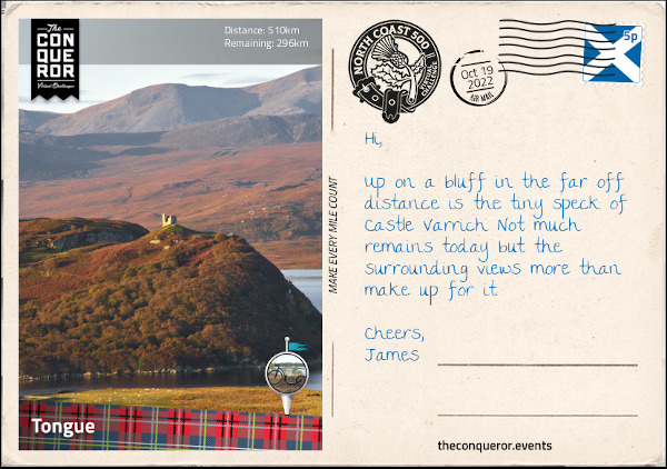
To the west of the village, high up on a bluff is Castle Varrich, the ruins of a small tower that was once the seat of the powerful Clan Mackay. Possibly built in the 14th century on the site of an Old Norse fort, the ruins have recently had a spiral staircase installed in the centre of the tower with a viewing platform at the top. From the top I can see the Kyle of Tongue and the mountains, Ben Loyal to the south and Ben Hope to the southwest.
Just north of the village is the House of Tongue, the chief seat of the Clan Mackay when they moved from Castle Varrich. The current house was built in 1678 by the Mackays after the previous house was burnt by Cromwell’s army 22 years earlier. However, in order to pay off debts the house and most of the Mackay estate was sold to the Sutherland family and today it is the Scottish home of the Countess of Sutherland.”
25th October 2022 – Thurso
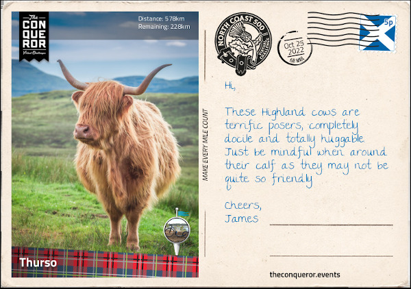
“Heading towards Thurso, I made a small detour at Melvich to visit a farm where I could have a close encounter with the completely adorable Highland cows. These shaggy cows with their long coats and long horns originated in the Highlands. They are known for their hardiness and ability to withstand the harsh conditions of northern Scotland. Their woolly hair is double coated with an oily outer hair (the shaggy part) that covers a downy undercoat. They can forage up steep mountain areas by grazing and eating plants that other cattle avoid and they can dig through snow with their horns to find buried plants. Bulls can weigh up to 1,800 pounds (800kg) and the females up to 1,100 pounds (500kg). They have a docile disposition unless they are protecting their young and are highly photogenic. With their ruffled, shaggy look, fringe over their eyes for protection these “Heilan coos” in Scots or “Bò Ghàidhealach” in Gaelic are a much loved Scottish icon.
About 5mi (8km) before Thurso, at the end of a dirt track near a working farm are the remains of Brims Castle. An L-shaped, 3-storey tower house, it was the property of the Sinclair Clan since the 17th century and occupied until the 1970s when the building’s roof collapsed and the property was abandoned. A ghostly story of a ‘White Lady’ is told to be of a woman who was disposed of by her lover by hiding her body inside the castle. On a lighter note though, Prince Charles is credited for being the artist of a watercolour painting entitled Caithness (which is the region the castle is in) that was displayed at an online art show. A long term resident of Thurso recognised the building in the painting as one of Brims Castle.
Thurso is the northernmost town in mainland Britain and it is located near Thurso Bay. Looking out north to the sea, I could make out the silhouette of the island of Hoy, one of the Orkney Islands and to the north east I could see the cliffs of Dunnet Head. The bay itself is open to the Atlantic swells making the area an attractive spot for surfing. Thurso is host to the annual Scottish National Surfing Championships and has also hosted two World Championships for Kayak Surfing. The bay and the sandy beaches makes Thurso a fabulous place for any water sport enthusiast.
Thurso is also home to one of the oldest churches in the country, Old Peter’s Church. It dates back to the 1100s and was altered and expanded many times over the next 700 years. In 1832 the church was abandoned and since then the roof has collapsed leaving the interior open to the elements. Surrounded by a wall the church and small graveyard was a quiet place for contemplation and peaceful meandering.
A short distance from the town centre bearing northeast are the ruins of the 19th century Thurso Castle. Originally a 12th century Viking stronghold, the castle was obtained by the powerful Sinclair clan and during the mid-17th century the castle was largely rebuilt. Disputes ensued with the Campbell Clan, another powerful family, and the castle was attacked and badly damaged. Eventually the dispute was settled and the castle repaired. By the mid-19th century the castle went through further changes until it was fully demolished and rebuilt into a Gothic style mansion. Unfortunately the castle caught fire and sometime in the early 1950s the roof was removed. A section of it is still habitable and it continues to be the home of the Sinclair family.”
31st October 2022 – Wick
“Satisfied with my “Heilan coos” encounter, my journey took me to the Castle & Gardens of Mey previously known as Barrogill Castle. Originally built in the 16th century by the Sinclairs, ownership passed out of the family to a Scottish zoologist, Frederick G Heathcote. He inherited the castle on the condition that he would legally change his name to Sinclair. The castle was sold to a Captain in 1929 and then sold again to the Queen Mother in 1952.
The story told was that the castle was in a tragic state and pretty close to demolition when the Queen Mother saw it. The owner at the time desperately wanted to get rid of the castle and just wanted to give it away, however, the Queen Mother wouldn’t agree to that and they settled on the purchase price of 100 pounds.
Restoring the property was a significant project as this was the first time that electricity, water and bathrooms were installed. Many of its 19th century additions were removed, the original name of Mey was reinstated and most of the works were supplied by local townspeople.
The Queen Mother visited the castle every year as part of her summer holidays. She would picnic on the beach each afternoon and collect shells which she would bring back to the castle and place in a bowl at the front door. The castle is now in the care of a Trust, helmed by [King] Charles and it is open to the public except for when the Prince and the Duchess are in residence.
Lying on Great Britain’s northeastern tip is the village of John o’Groats and it may be mistaken as the northernmost point but that credit goes to Dunnet Head not far from Thurso. The village is famous for its long distance route across the length of Britain – named Land’s End to John o’Groats [ I did that as a challenge previously, blog entries can be found here ] – with the other end being at the southwest corner in Penzance. It is also known for its long-distance walking route called John o’Groats Trail which begins in Inverness and travels north along shorelines, cliff tops and back lanes. The iconic signpost found near the local hotel marks the Journey’s End and a great place to wrap your arms around when a strong wind blows through the wide open space.
This marks the end of the northern portion of NC500. Now I start the east coast portion of the route travelling south towards Wick. A few stops were needed along the way to see several coastline castles. Best do a quick roundup as I’m sure each has a long and distinguished piece of history.
Freswick Castle was built by the Sinclairs in the 16th century on the site of an old Viking settlement. As typical with many castles various alterations took place through the following centuries and the castle remained in the family until the 20th century when it entered a period of decline. Located on the shores of Freswick Bay, the castle was purchased in the 2000s to serve as a family home. Following extensive renovations the property was opened for overnight stays.
A mere 1.3mi (2km) away are the ruins of Bucholie Castle. Located on a promontory that is accessed by a very narrow isthmus with sheer drops on either side, the site originally had a fortress called Lambaborg that was built around 1140 by the notorious Viking pirate and robber, Sweyn Asliefson. Castle ownership moved to the Mowat family around the 13th century and remained in the family until 1661 when it was abandoned and fell into disrepair. Not much is left of the castle but for a daring adventurer crossing the isthmus and then climbing up to the entrance to explore the remains on the promontory would be quite the experience.
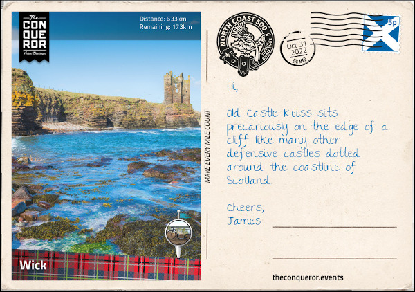
Standing on sheer cliffs overlooking Sinclair Bay is the partially ruined Old Keiss Castle. Initially built as a square tower house with towers on diagonal corners, the castle had four floors, an attic, a vaulted basement and tall chimneystacks. Built around the turn of the 17th century by the Sinclairs it seems the castle fell into ruins within a century and instead of repairing it the family moved and built the nearby Keiss House. Sadly a portion of the old castle collapsed when the cliff below it fell. What remains of it seems to be on borrowed time.
Making my way into Wick I went out and explored the last two castles that were both within very close proximity to the town. To the north of the town located on a rocky promontory is Castle Sinclair Girnigoe. It was a 15th century five storey building with a walled courtyard, a gatehouse and drawbridge (now replaced by a footbridge) to cross the ditch that cuts off the promontory. The size of the original castle was significant and at one point it was thought to be two separate castles near each other, one called Sinclair and the other Girnigoe. This assumption was a result of another drawbridge that was located between two main buildings and a dry moat that separated them. Those who visited just simply assumed they were two castles. However, following archaeological studies it was concluded that it was indeed just one castle. It is not clear what happened to the castle in the end but an archaeological survey is ongoing and perhaps one day the puzzle will be solved.
South of Wick is the very ruinous state of Castle Wick. Very little is left of it but it is one of the oldest structures in Scotland having been built in 1160 at the height of Norse power. Sitting on a narrow promontory the castle was a single tall tower or keep and the surrounding grounds would have had several buildings to accommodate servants, workshops, stables, kitchen and what was necessary to manage the needs of the lord and his family. Whilst not much remains a meander gives way to expansive views across Wick Bay and the North Sea and somewhere in the distance is the coastline of Norway.
Scotland is renowned for its vast collection of castles. Somewhere upward of 2,000 castles existed. Of course many have perished by now. Primarily built for defense against invasion the castles were built in strategic locations. However, their ability to remain a stronghold was decimated when gunpowder was invented and their defensive capability diminished. With time and changing needs their original designs as fortified castles gave way to luxurious mansions of which many continue to exist today and are inhabited by the descendants of their original clan owners.“
On the 2nd November I reached the 80% completed point of the challenge. Only 20% more to go and I would finish.
6th November 2022 – Golspie
“Always curious about unusual locations, I just had to check out Whaligoe Haven and its narrow, steep set of steps. Surrounded by 250ft (76m) cliffs on three sides, the haven was used as a fishing station. Entry to the harbour was quite treacherous with ships having to moor against rocks whilst fishing boats had to be pulled out using a winch. The local residents had no choice but use the haven as there were no alternative nearby options.
Access to the harbour was via a steep descent of some 300+ steps (there seems to be some debate as to precisely how many) in a zig-zag formation. It was built around the mid-18th century for a total of eight pounds. The steps are made of stone and whilst in excellent condition they can be hazardous on wet days, particularly since the seaward side of the steps only has a low stone wall and quite a sheer drop. A good head for heights and surefootedness is certainly necessary. The hillside of the steps is quite pretty, densely filled with wildflowers amongst grassy patches and rockface. At the bottom are remnants of a hand powered winch that was used to haul up the fishing boats and the ruins of a salt store that was used to cure the fish. Whilst usage of the harbour declined over time until it ceased altogether in the 1960s the steps themselves continue to be maintained by local volunteers.
From the shores of Dunbeath Harbour I could see across the bay the striking Dunbeath Castle. Built in the 13th century and expanded on, the white castle stands out amongst its green grassy surroundings and rocky shores. It is a private residence where only the gardens are available to explore. A very long driveway leads to the residence as it passes two walled gardens, each with their own theme. The upper garden, is located on a bank and was designed for serenity and peace as one meanders past its various pools and swaying grasses. The lower garden is brimming with colour and floral displays in perfectly executed garden beds filled with roses, dahlias, lupins, hostas and geraniums to name a few.
Across the river from the village of Helmsdale is The Emigrants monument in memory of the Scottish people who left the shores of Scotland in search of a better life following the Highland Clearances (c1750-1880) when large numbers of Highlanders were displaced from their lands. The statue is of a family consisting of a kilted man looking ahead into an unknown future, a boy looking up at him for reassurance and a woman holding a baby facing the opposite way towards a home they were forced to leave. The inscription on the monument evokes a lot of emotion for those times and it reads:
The Emigrants commemorates the people of the Highlands and Islands of Scotland who, in the face of great adversity, sought freedom, hope and justice beyond these shores. They and their descendants went forth and explored continents, built great countries and cities and gave their enterprise and culture to the world. This is their legacy. Their voices will echo forever through the empty straths and glens of their homeland.
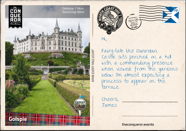
Just before reaching my next destination, the village of Golspie, I took another detour to visit the last castle on my journey, the fairytale-like Dunrobin Castle. Located high on a rocky spur it is the largest castle in northern Highlands. Whilst its history is a difficult one due to their extensive involvement in the Highland clearances, I chose to appreciate the castle and its gardens from an architectural point of view. The entrance to the castle wasn’t particularly impressive until I walked around the side of it to the rear and found myself on a large upper terrace. Here I admired the grand chateau-like structure with its conical spires overlooking the formal gardens below and views of Moray Firth beyond. The castle has been in the same family for nearly 700 years and it has a whopping 180 rooms. Decorated with period pieces, there was lots to see inside from painted friezes, wood panelling, armoury display and in the old summer-house at the rear of the garden was the museum exhibiting the family’s collection of artefacts from their travels.
Golspie is a seaside village located on the North Sea coast. It is overshadowed by nearby Ben Bhraggie, a hill right behind the village. The hill is 1302ft (397m) tall and right at the top is a 100ft (30m) tall monument of the first Duke of Sutherland. The monument was erected in 1837 and is visible from far and wide perched up on the hill. The village has a long sandy beach which seemed like a good place to pause and enjoy the sea views.”
15th November 2022 – Inverness
“Continuing south I crossed the Dornoch Firth Bridge into the village of Morangie where the Glenmorangie Distillery has been producing its single malt whisky since 1843. The distillery has its own water source, the Tarlogie Springs, and the tallest stills in Scotland. The copper stills at 26ft (8m) with “necks as tall as a giraffe” are used for distilling the spirit and it is said that it is meant to create “more space for taste and aroma”. …
At the Ardullie roundabout shortly before the town of Dingwall, I took a left turn onto Cromarty Bridge and crossed Cromarty Firth. The mile long bridge was built in 1979 significantly shortening the route from the north into Inverness and bypassing major towns such as Dingwall, Muir of Ord and Beauly.
The Cromarty Firth is an arm of the Moray Firth. Several oil rigs occupy space at the entrance to the firth and facilities for cruise ships, oil processing and bulk cargo handling can be found along the firth.
The firth is also designated a Special Protection Area for wildlife conservation where dolphins, porpoises and seals live and minke whales migrate to seasonally. Larger marine animals such humpback whales and common dolphins may visit at times. Once across the bridge, I took a winding southeast direction across the Black Isle peninsula through several small villages until I reached North Kessock where I crossed yet another bridge across Beauly Firth.
Kessock Bridge is 3,456ft (1,056m) long and since the firth beneath it is navigable the bridge is raised high over sea level. It has four towers with cables running from the top to the deck supporting the bridge. The cables have a fan-like appearance making it visually appealing over Inverness’ skyline, especially when the bridge is lit at night.
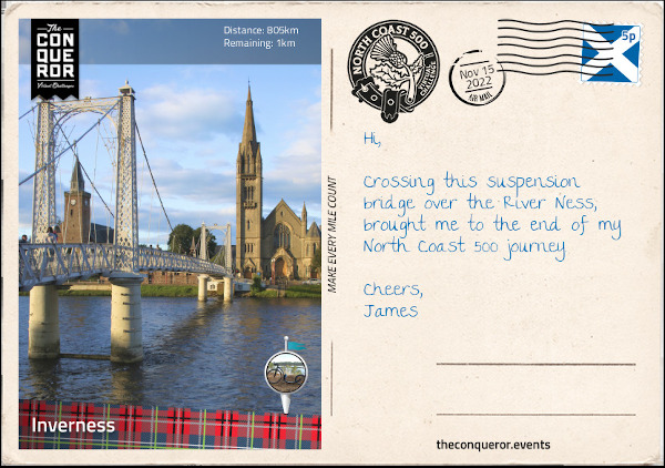
I finished my journey near Ness Bridge on the opposite side of the river from where I began having completed 500mi (805km) around the north-western Highlands. The North Coast 500 was a combination of hair raising experiences on single track roads, splendid panoramic views, castles rich in history and numerous lochs, sheer cliffs, mountains and pristine beaches.”
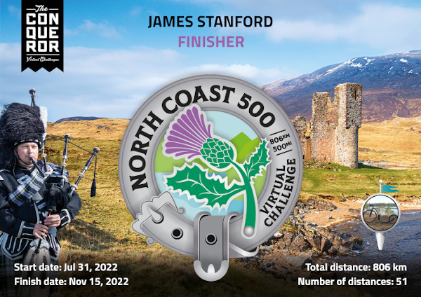
Challenge Statistics:
- Total Distance: 805.5km.
- Allocated time to complete: 210 days (30 weeks).
- Completed in 107 days (51% of allocated time).
- Number of rides: 51.
- 253.9km (31.5%) done on a 20″ K-Rock foldable bike.
- 551.6km done on Kickbike.
- 15.8km avg ride length.
You May Also Like