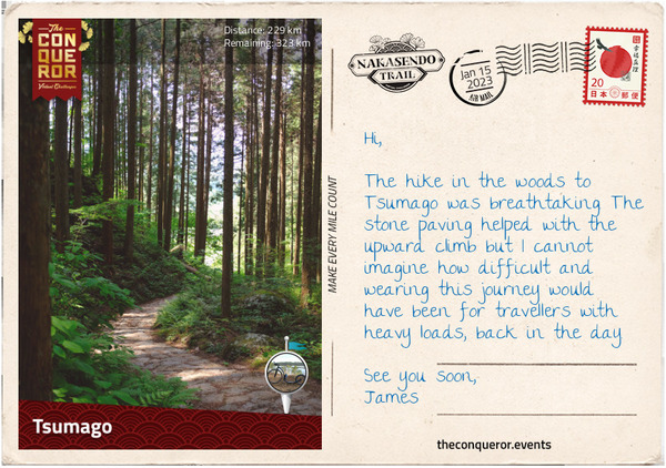
Nakasendo Trail Virtual Challenge
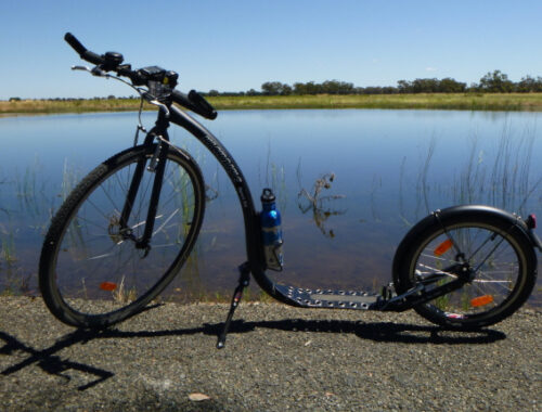
On 1st January 2023, I started the Conquerors Nakasendo Trail virtual challenge. I did it as a Kickbiking challenge, and have set myself 10 weeks to complete it, which means a finishing date of 12th March. I need to average 56km a week to finish it in the allotted time. Unless otherwise indicated, the information and photos for this blog post are derived from The Conqueror postcards emails (for Postcards) or The Conqueror mobile app (for Local Spots).
“Japan … is made up of four major islands and several smaller ones. Honshu is one of the four main islands where the current capital Tokyo, previously known as Edo, and former capital Kyoto, are situated.
It is on Honshu that the famous Nakasendo Way, also known as Kisokaido, was established by shogun Tokugawa Ieyasu. Known as one of the three Great Unifiers of Japan, Ieyasu was a powerful shogun in the early 1600s, who established a central government in Edo. To maintain order and control over the local feudal lords (aka daimyo), the Tokugawa shogunate had a policy requiring the lords to alternate living for a year in their domain and then in Edo. As such, the shogunate constructed five official routes that connected Edo with its outer provinces. One of those routes was the Nakasendo, which can be translated to Central Mountain Route, that began at Nihonbashi Bridge in Edo, travelled through the centre of the island, over several mountain passes and finished at Sanjo Ohashi Bridge in Kyoto.
To service the travellers’ accommodation and transportation needs, a system of 69 post-towns was set up on the route between the two main cities. Most towns had three different types of inns: honjin –reserved only for the daimyo or high-ranking officials; waki-honjin – reserved for lower ranking officials; and hatagoya – used by ordinary travellers.
The post-towns were on average 5-6 miles apart (8-10km) apart and the roads were maintained by the local lords. They were typically ‘one-street towns’ with the Nakasendo as the main road. Sometimes the street meandered in a snake-like fashion or took a sharp turn as a way to slow down any potential enemies wanting to make their way into Edo.
Pine and cypress trees were planted along the road to provide shade in the summer and protection from the cold in the winter. Distance markers were placed at regular intervals, around every 2.5mi (4km), often in the shape of large earthen mounds with a tree planted on top.
The whole expedition would take on average two weeks, of course much of that was dependent on the size of the retinue, age and health of the travellers and the load being carried. Crossing nine mountain passes made it more difficult as they were typically narrow and steep. Some sections were paved with stones to help the travellers and make it easier to maintain. Harsh winters added to that complexity.
The journey I am embarking on begins in Kyoto and ends in Tokyo. Kyoto is an ancient capital city having been the seat of Japan’s imperial court for 1,100 years (769-1869 AD). The capital was moved to Tokyo following the fall of the Tokugawa shogunate.” (from first Conquerors postcard for the challenge).
1st January 2023 – Kyoto
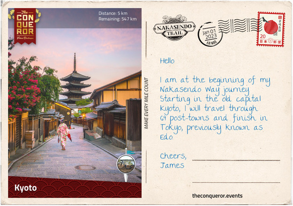
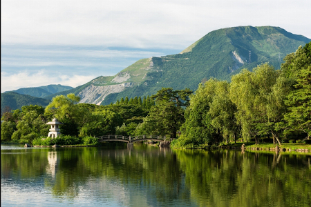
“Kyoto is home to 17 UNESCO listed sites that include a number of temples; Nijo Castle – the Tokugawa shogunate’s Kyoto residence; and the 6th century Shimogamo Shrine – one of the oldest Shinto shrines in Japan. Kyoto is also where the famous 1,000 Torii Gates are located, within the Fushimi Inari Shrine. The vermillion gates cover a network of hiking trails through the woodlands of Mount Inari.
As I head east, I will meander through the cobblestone streets of Higashiyama Ward. The narrow lanes of this historic quarter are lined with traditional wooden buildings, beautifully restored and preserved, as a reminder of Japan’s feudal era.”
1st January – Nijo Castle local spot
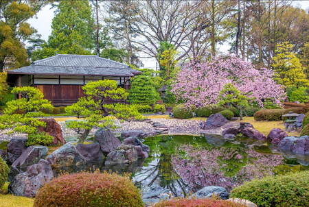
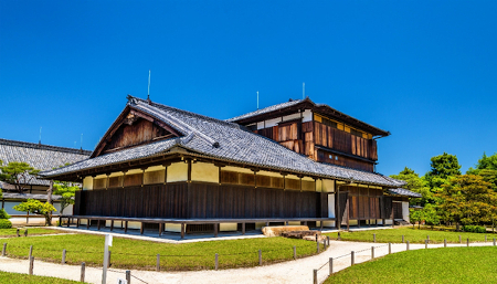
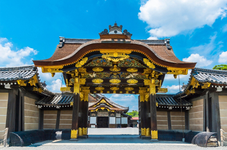
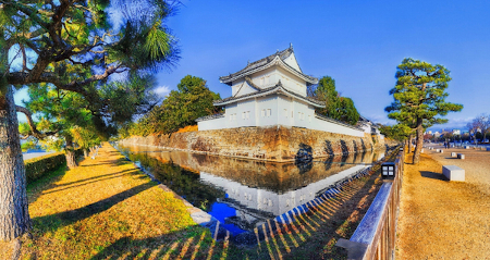
“Nijo Castle was built over 25 years in the early 1600s, beginning with the first Shogun, Tokugawa Ieyasu and his grandson. The castle was the shogunate’s stronghold for 250 years until it ceded power to the Imperial Court. In 1939 the castle was donated to Kyoto and opened to the public. In 1994 the castle was inscribed on the World Heritage List.”
1st January 2023 – Senbon Torii local spot
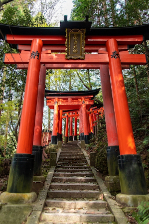
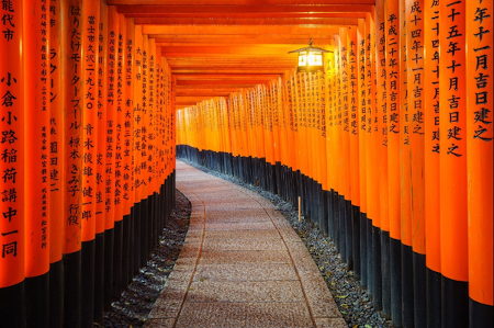
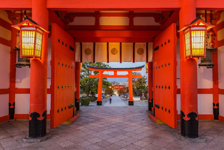
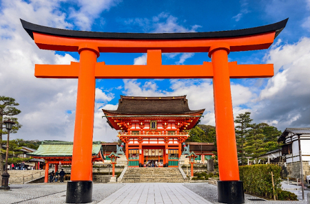
“The Senbon Torii is famously known for the rows of 1000 torii gates in bright vermillion red hues. The torii gates straddle a network of trails behind the main buildings of Fushima Inari-taisha shrine. Since the Edo period it has been customary to donate a torii and express prayers and gratitude. Each torii is inscribed with the donor’s name and date of donation.”
2nd January 2023- Lake Biwa local spot
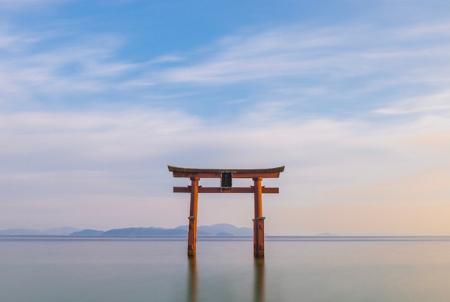
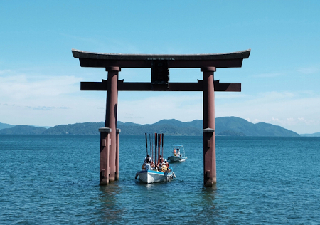
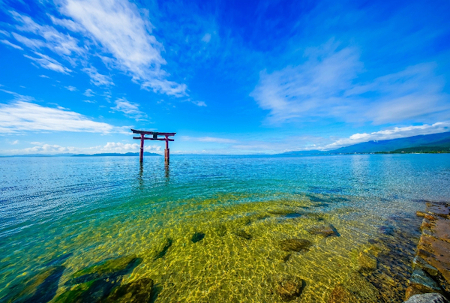
“The striking Shirahige Shrine Torii sits within Japan’s largest body of fresh water, Lake Biwa. It was here on a moonlit night that the world’s first novel, The Tale of Genji, was being written by Murasaki Shikibu in the 11th century. Ukimido Hall, at the end of the pier is a place of worship, praying for the safety of lake travellers.”
2nd January 2023 – Omihachiman
“Travelling to Nakasendo, one of the first things I had to learn is that many of the post-towns go by different names today. During the Edo period, the towns had -juku or -shuku on the end of their name, indicating it was a post-town. For instance, the very first post town after leaving Kyoto was known as Otsu-juku (#69). Today, it is just simply known as Otsu.
Otsu was and still is an important town due to its proximity to Lake Biwa, the largest body of freshwater in Japan. Otsu was also Japan’s capital for a brief period during the 7th century.
The next stop was Kusatsu-juku (#68), now Kusatsu, a very busy town because it was at the junction of two major highways, Nakasendo and Tokaido, which ran along the southern coast of Honshu Island. Being an important station, it had 74 inns. One of them has been restored and turned into a museum whilst another is a restaurant known for its soba buckwheat noodles.
Moriyama-juku (#67), now Moriyama, was a day’s travel from Kyoto and many travellers preferred this station over Kusatsu-juku which was always busy. Very few old buildings survive. One of them was once a sake brewery during the Edo period, then the childhood home of former Prime Minister Sosuke Uno and now it operates as a museum.
On my way to Omihachiman, previously known as Musa-juku (#66), I passed Mount Mikami, which is often nicknamed Omi Fuji due to its conical shape and similarity to Mount Fuji. However, Mount Mikami is really only a hilltop at 1417ft (432m) and doesn’t compare to Japan’s most sacred mountain.
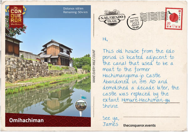
When Musa-juku was a post-town, the surrounding countryside was relatively flat with several rivers needing to be crossed. One such river, the Hino-gawa, was traversed via a pontoon bridge made of wooden planks, tied together with ropes and supported by a series of boats. The pontoon bridge is long gone now but the path leading to the old location still exists.
Several houses and waki-honjin have survived that can be viewed by meandering through the north end of Shinmachi Street or from Haku’un-bashi Bridge. The canal that flows beneath the bridge had a dual purpose. First, as a moat protecting the Hachimanyama-jo Castle and secondly, as a transport route connecting the town to Lake Biwa.”
2nd January 2023 – Echigawa
“Leaving Omihachiman, for the next 6mi (10km) I pass by rice fields and as I reach Goka, I pass some old textile factories. The area between Goka and Hikone was well known for cotton and flax production during the Edo period with many of the wealthy merchants living around Goka. Building large mansions, those that survived are now open to visitors to explore. Southwest of Goka are the ruins of the 16th century Azuchi Castle. When the castle was built, it was considered revolutionary in terms of architecture. Most castles were built for defensive purposes, but Azuchi was meant to be a large mansion. It had a 7-storey keep with the upper floor being octagonal. Where the castles were typically painted white and black, Azuchi was colourfully decorated with tigers and dragons. Commissioned by shogun Oda Nobunaga, the first Great Unifier of Japan, the castle was built in 1579 AD. Following Nobunaga’s assassination, the castle and all its glorious decorations were demolished three years later. Reconstructions of the octagonal room and the top floor are on display in a museum near the ruins along with a model of the castle.
I travelled through Echigawa-juku (#65), now part of Aisho city, which was named after the river running through it. Villagers and travellers had to walk through the river to cross it, until a local businessman built the Miyuki Bridge in 1831. A signpost used to stand beside the bridge indicating that crossing was free of charge – paying to cross a bridge was customary practice.
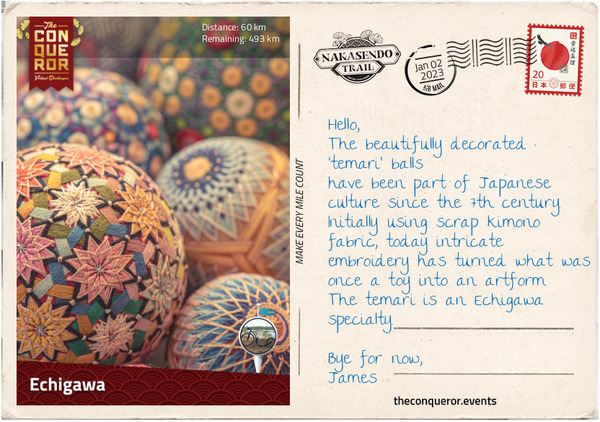
Today Echigawa is known for its temari, a decorative handball made from old kimonos and scraps of silk that became popular during the Edo period. Temari balls were traditionally gifted to children on New Year’s Day but have now been elevated to a work of art due to their many beautiful and intricate patterns. Sometimes a hand strap and tassel were added to the ball to turn into an accessory for a kimono.
One of Echigawa’s longest running businesses is Takeheiro, an inn and restaurant that has been operating continuously since 1785 AD. Emperor Meiji, who ended the Tokugawa shogunate, is said to have rested here during his reign.”
4th January 2023 – Hikone
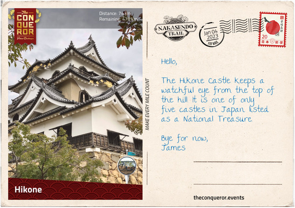
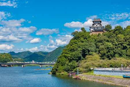
“Current day Hikone is a major city that includes two former post-towns, Takamiya-juku (#64) and Toriimoto-juku (#63). The area was a strategic point for protecting the capital from attack. Following shogun Tokugawa’s victory at the Battle of Sekigahara (next postcard), he made his most trusted adviser and capable general, Ii Naomasa, daimyo of the Hikone Domain and with that Ii Naomasa was given Sawayama Castle. Naomasa disliked the castle because it had been the home of his enemy and decided to demolish it and use it for parts to build Hikone Castle. Originally the Hikone Castle was on the shores of Lake Biwa but due to land reclamation the castle’s location is now inland about three-quarters of a mile (1km).
Hikone Castle isn’t particularly large when compared to others throughout Japan, but it is one of the few original castles that were spared when the feudal era was abolished, and it was left largely intact. Naomasa began construction of the castle in 1602 but after his death due to injuries sustained in battle, it was fully completed by his son in 1622. The castle remained in the family until 1944 when it was donated to the city of Hikone. Fortunately for the city and the castle, in 1945 the area was scheduled for an air raid but the war ended on the same day at noon and the bombing was not conducted.
Painted in black and white like most Japanese castles, it was constructed out of wood, stone, plaster, and tile. It is surrounded by a double moat and the inner enclosures are divided into three sections, each one accessed by a bridge over a dry moat. In the 20th century, the inner Palace was fully rebuilt and the grounds were planted with over 1,000 Yoshino cherry trees, a visual feast when blooming in spring.
Takamiya-juku was established in the 7th century, and it was the first town to be granted official status as a post-town. In the centre of town is a massive 36ft (11m) by 29ft (9m) wide Torii Gate with a large stone lantern.
Toriimoto-juku was a market town that used to have two teahouses up on a hilltop. With commanding views of Lake Biwa and Mount Hira in the distance, it would have been an amazing resting point. Today only the foundations remain with limited glimpses of the lake.”
6th January 2023 – Battle of Sekigahara

“The next three post-towns, Banba-juku (#62), Samegai-juku (#61) and Kashiwabara-juku (#60) merged into present-day Maibara.
Banba was a resting point for travelling merchants. Located in a valley, sometime in 1611 a cutting through the hills opened up access to the port on Lake Biwa. It helped travellers who could afford it to complete their journey with a lake crossing, reducing their travel time by two days.
Since the 10th century, Samegai has been renowned for its clean spring waters. By the Edo period the spring was used for goods transportation and the banks were lined with warehouses. Today, the canal is a calm and serene spot. During May to August, the surface of the water blooms with small white flowers referred to as water buttercups, whilst beneath it thrives with freshwater fish called hariyo, a type of stickleback species.
Kashiwabara is one of the oldest post-towns having been in service since the 11th century. It also had the longest street at over one mile (1.6km) lined with houses on both sides. Many buildings from the 18th-19th century survive but only a handful have been restored. The Kameya pharmacy has been in operation since 1616 AD and inside the store is a statue of Kintaro, a child folk hero with superhuman strength. It is customary to put up a Kintaro doll on Boy’s Day in the hope that boys will become brave and strong.
As I wandered through the post-towns of Imasu-juku (#59) and Sekigahara-juku (#58), both merged into modern-day Sekigahara, I progressed towards the famous battlefield that ended the Sengoku Period and gave rise to the Tokugawa shogunate and the start of the Edo Period.
The Battle of Sekigahara in 1600 AD was fought between the Western army led by Ishida Mitsunari and the Eastern army led by Tokugawa Ieyasu. Regarded as the most important battle in Japan’s feudal history, it lasted a mere 6.5 hours. Beginning early in the morning, the Western army took position on high ground west of the village whilst the Eastern army was approaching from the east.
A heavy fog delayed the battle but as it lifted Ii Naomasa and his troops (Eastern army) – known as The Red Devils because of the blood red suit of armour they wore in battle – joined by Masanori’s advance guard, charged the Western army through the centre and the left flank. Although Masanori made progress, he later became exposed and Naomasa was shot by a long gun. Both had to stop further pursuit.
During this time a Western army high ranking officer, Hideaki, who had secretly taken a bribe from Ieyasu defected to the East army. Along with 15,000 men, Hideaki attacked the Western army. Consequently, four more Western army units defected.
Those left on the Western side fell back, unable to hold their positions anymore, leaving Mitsunari completely exposed. By lunchtime, Mitsunari fled, but he didn’t get far as he was caught by villagers and later beheaded in Kyoto.
With the fall of the Western army, Tokugawa Ieyasu became the first shogun, founding a dynasty that ruled for 250 years.”
6th January 2023 – Mt Ibuki local spot
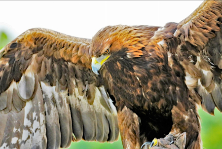
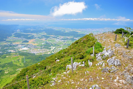
“Mount Ibuki is the tallest mountain in Shiga Prefecture. From it’s summit it has spectacular uninterrupted panoramic views including that of Lake Biwa. It’s alpine flower fields are a national natural treasure and the mountain is home to the Japanese Golden Eagle.”
8th January 2023 – Gifu Castle local spot
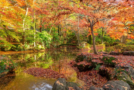
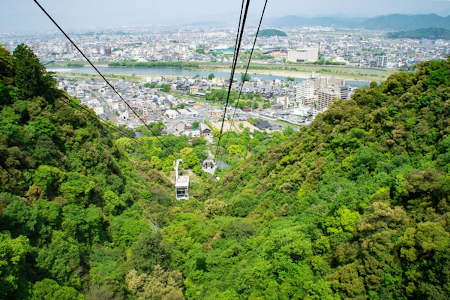
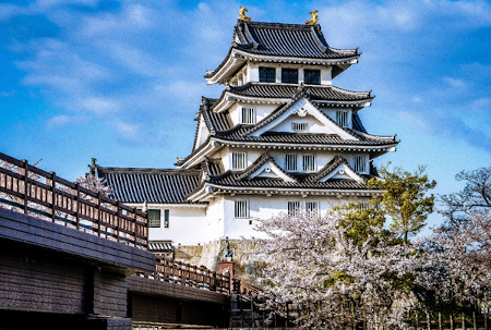
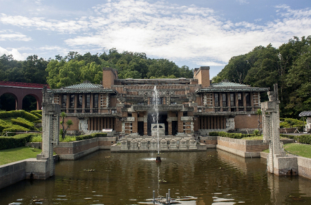
“Perched on a hill, the current Gifu Castle is a reconstruction of a 16th century castle that was bombed during WWII. An observation deck on the top floor affords stunning views of the Nagara River and the city of Nagoya. Besides the trail, the castle can be accessed via a cable car from Gifu Park. The park is known for it’s seasonal displays, especially it’s autumn colors.”
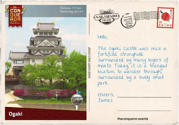
8th January 2023 – Ogaki
“Leaving Sekigahara, I entered the extensive Nobi Plain and headed towards former post-towns Tarui-juku (#57) and Akasaka-juku (#56). The extensive Nobi Plain is surrounded by a chain of mountains that is broken to the west of Sekigahara, making it the only practical mountain pass for the Western and Eastern armies to battle it out and determine who would rule Japan. The pass was also the main connection between east and west and a thoroughfare for the transportation of goods. Today, it continues to maintain the connection with several train lines, including the bullet express and the national highway, passing through it.
Travelling along a quiet and narrow section of Nakasendo, I pass by small villages, a few suburban houses and occasional stretches of countryside. Some of the surviving trees that lined the Nakasendo have bright bands around them, signifying their historical importance. A short distance away, I arrive in Tarui, one of the oldest post-towns, having been in service since the 12th century, that is at the junction of the Nakasendo and the Tokaido roads. Three miles further (5km), is Akasaka, a marble mining town where locals used to make small marble trinkets in their spare time to sell to passing travellers. Both post-towns were absorbed into the city of Ogaki.
Ogaki used to be a castle town with an initial focus on military activity and was later a political and economic centre. Nearly half the population were military (samurai). Given the strict hierarchical order at the time, each castle town was specifically organised. In Ogaki at the centre, up on a hill was the castle – the daimyo’s home – surrounded by several layers of moats with a central keep and corner watchtowers. Adjacent to the castle, usually between the first and second moat, were the homes of the samurai. The townspeople were on the outskirts, with each group such as merchants, soldiers, labourers, artisans located in their own specific ward.
Ogaki Castle wasn’t particularly large but it was well fortified and during the Battle of Sekigahara it was used as headquarters by the commander of the Western Army. Drawn out of the castle and into battle, after a short skirmish the castle fell, with Todo Ujikane from the Eastern Army taking up lordship and control of the fief. His clan would remain in power until the end of the Edo Period.
In WWII the keep and watchtowers were bombed and completely destroyed. Replicas were constructed in 1959 with the keep as a museum displaying the history of the castle and various samurai arms and armour. Today, the castle is surrounded by a small park filled with several statues of historical figures including a fine equestrian statue of Todo.”
By January 8th, I had already completed 20% of the challenge.
9th January 2023 – Sanko Inari Shrine
“Located in the centre of the Nobi Plain was the infamous post-town of Mieji-juku (#55), now Mizuho. During the Edo period it was subject to constant flooding causing travellers much angst. The den of gamblers, thieves and numerous saloons gave Mieji a terrible reputation.
The next post-town, Godo-Juku (#54) was a minor town with only a handful of inns. It was located near Nagara River and known for cormorant fishing, a fishing technique where trained cormorants (birds) were used to catch fish in rivers. The fishing masters on the Nagara River are the only ones listed as the Imperial Fishermen of the Household Agency, a government agency that takes care of state matters for the Imperial Family.
Whilst tourism and trade increased in Godo, unfortunately the town didn’t benefit from it and with a new bridge installed further downstream, trade was taken away from the town. Very little remains as a reminder of its past.
Crossing the bridge, I left the Mino plains behind and in the distance to my left, I saw Gifu Castle, sitting precariously on top of the hill as I made my way into Kano-juku (#53) – together with Godo, Kano is now part of Gifu city. For a time, Kano was the local centre of activity and one of three places that served as both a castle-town and post-town. Kano’s road had numerous sharp turns – resembling the letter “M” – for defensive purposes preventing the enemy from seeing the way ahead. Today, Kano is a well preserved old town, as the local government moved back to Gifu after the Edo period ended.
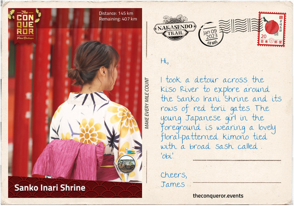
A few miles further, I arrived in Unuma-juku (#52), now Kakamigahara, a small post-town that never expanded because of its proximity to Inuyama castle-town across the banks of Kiso River. Cormorant fishing can be observed from the traditional inns and restaurants located near the river. Kiso River is what gives Nakasendo the alternative name of Kisokaido.
Before I continued on my journey, I took a short detour across the river to visit Inuyama Castle and the Sanko Irani Shrine.”
9th January 2023 – Meiji Mura Museum local spot
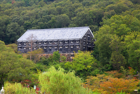
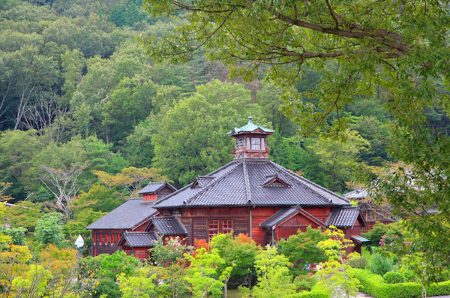
“Meiji-Mura is an open air museum preserving 60 notable historical buildings built between 1867 and 1989. It includes: 1) lobby of Frank Lloyd Wright’s Imperial Hotel (1923); 2) oldest surviving western-style prefectural office (1879); 3) Kanazawa Prison Central Guard Station (1907); and Hirose Sake Brewery (1868).”
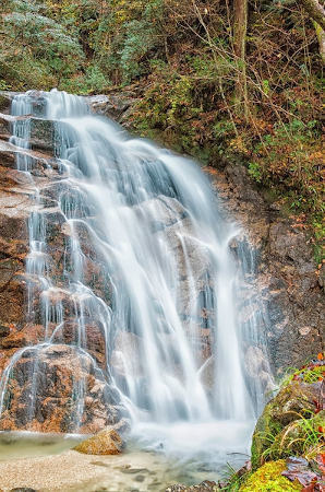
11th January 2023 – Gohou Waterfalls local spot
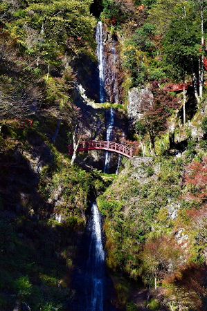
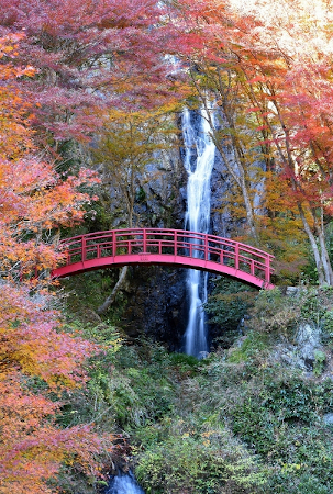
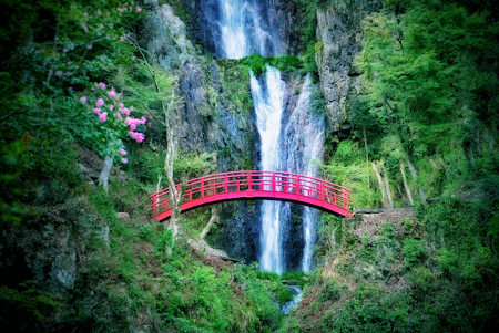
“Gohou Waterfalls is located near the town of Yaotsu. It is a series of five waterfalls with a total drop of 262ft (80m). It has a red arched bridge that during the autumn season beautifully encapsulates japan’s landscape.
Many Israelis visit the area, as it is close to the Sugihara Chiune museum, that tells the story of the Japanese diplomat who saved thousands of Jews while working in Lithuania during WWII”
11th January 2023 – Tsubashi
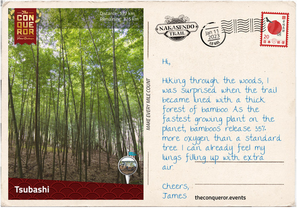
“I travelled along the banks of the Kiso River to Ota-juku (#51), now Minokamo, with delightful views of the river that was briefly interrupted by a short jaunt through a forest with a narrow trail beautifully paved in stone.
Ota was an important local administrative centre ruled by one of the strongest clans in Japan that was affiliated with the Tokugawa shogunate. Located at the confluence of Hida River and Kiso River, Ota was also an important river crossing location. Flooding was common after the snow thawed, making the crossing and this section of the journey one of the most difficult.
There is a famous story of Princess Kazu Chikako, who in 1862 travelled from Kyoto to Edo along the Nakasendo to get married to shogun Tokugawa Iemochi. Her retinue of 25,000 men banked up the highway creating a traffic jam that lasted for weeks. When she arrived in Ota she stayed at the local inn. Although her nuptials were arranged to repair the relationship between the Imperial court and the Tokugawa shogunate, her brief marriage to Iemochi was a happy one. When Iemochi died three years later, Princess Kazu became a nun and spent her days writing poetry and calligraphy. Memorial stones along the Nakasendo commemorate her journey.
The town of Mitake holds within its borders two former post-towns: Fushimi-juku (#50) and Mitake-juku (#49). Interestingly, Fushimi-juku was the last post-town built, whilst its neighbour Mitake-juku was the first official post-town on the Nakasendo. Fushimi was created in 1694 when the flow of the Kiso River shifted and a new location for ferries to cross the river was needed further upstream. It prospered for a while but with other nearby post-towns it remained small. Whereas Mitake-juku was built in the early 800s and served as a post-town for older routes before becoming part of the Nakasendo.
Passing through several hamlets, I entered the woods on a narrow and rugged trail. A thick forest of bamboo lined parts of the route and then it commenced a steady climb towards the next post-town.”
13th January 2023 – Sakaori Terraced Rice local spot
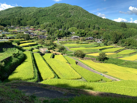
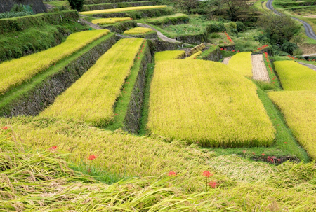
“The Sakaori Terraced Rice fields in Nakanoho are nestled between two mountains. Built during the Edo period, they are more than 400 years old. The terraces were built using advanced stone masonry and they spread out in the shape of a fan. To maintain the traditional landscape, locals have taken great pains to improve their roads and provide easier access to the fields. In 1999 it was certified as one of the ‘100 Best Rice terraces in Japan’ “
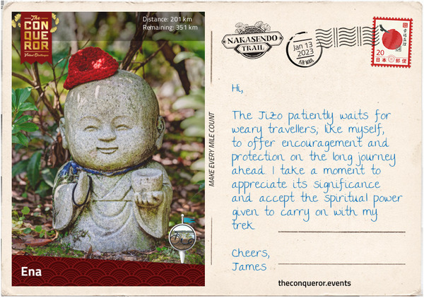
13th January 2023 – Ena
“Surfacing from the woods, I arrived in Mizunami and its former post-towns Hosokute-juku (#48) and Okute-juku (#47). In between the two post-towns was Biwagi-pass, a very difficult pass to cross, mostly due to frequent inclement weather rather than the road itself. Stone paving was laid in this section to make it easier for the traveller to traverse and minimise the slipperiness.
The trail through the pass is lined with Jizo statues. The stone statues are shaped to look like children but in essence they are the image of Jizo Bosatsu, guardian deity of children and travellers. A kind and patient deity, the Jizo maintains a double duty by protecting travellers on their journey and also the spirits of dead children who are unable to cross the river into the afterlife. Jizo protects the children from the mean spirited Yokai by hiding them beneath his clothes and becomes their caretaker in place of their parents.
As the weather cools, locals dress the Jizo statues with red bibs and hats as a way of earning credit to get into the afterlife. The colour red is said to keep away sickness and danger, making it an appropriate colour to dress the deity.
I made my way into Ena, where the former post-town Oi-juku (#46) continues to exist as a suburb. Oi is located in the foothills of the Japanese Alps where the winters are extremely cold and very snowy. The area is well preserved with the typical sharp-turns in the road to deter enemies. Parts of the highway date back to 1100 AD. The gateway to the former honjin and several regular inns have survived to this day, including the 400 year old Ichikawa Ryokan, formerly Kakuya Inn, that continues to be in business today.”
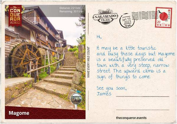
15th January 2023 – Magone
“The city of Nakatsugawa is a thriving market town with a small industrial centre. It consists of three merged former post-towns: Nakatsugawa-juku (#45), Ochiai-juku (#44) and Magome-juku (#43). To the north is the winding Kiso River and to the southeast is Mount Ena with its hiking trails.
The post-town of Nakatsugawa-juku was also a busy market town and trading centre. It was one of the largest towns in the Edo period, with several shops selling rice, sake, soy sauce and salt, amongst other things. It had more than 30 inns, compared to the small towns that averaged about 8 inns.
The Hazama Sake Brewery has been making sake – a fermented rice drink with koji and water – in Nakatsugawa-juku since the 18th century. The brewers are the Ma family, originally a samurai family, moved to the area after the Battle of Sekigahara and became one of the wealthiest merchants of the Tokugawa shogunate. The brewery has an enviable view of Mt Ena but even better it has an abundant flow of clean, underground water that is used in the brewery. Calling the sake Mt Ena, their intent is to create a drink as pure and clear as the water.
Ochiai-juku was a small post-town and was dwarfed by its neighbouring Nakatsugawa-juku. It had only half the inns and a third of the population. The honjin survives in pristine condition but nothing else remains.
At the eastern end of Ochiai-juku is a large stone lantern that was used to light the way. Stone lanterns were located at both ends of a post-town and were lit from dusk till dawn. They were known as joyato, translated as “all-night lights”. Similar lanterns are also found outside shrines.
Stone lanterns, known as Toro, can be found all over Japan. They originated from China and were initially used in Buddhist temples only, lighting the paths. The lit lanterns were considered an offering to Buddha. Between the 8th-12th centuries they became part of Shinto shrines and private homes and then the tea masters popularised their use by having them as garden ornaments.
Leaving Ochiai-juku, the highway starts to climb and soon I find myself on a stone paved trail in woodland, with the sun streaming through the trees. It is short-lived and as I keep moving forward, wonderful rolling hills present themselves and soon after, I arrive in Magome-juku.
Magome is a rebuilt town – having been destroyed by fire in 1895 – using traditional architecture that preserves the feel of the Edo period. It is a very popular tourist location with shops lining both sides of the street. Closed to vehicular traffic, the walk up the street, whilst very steep indeed, is beautiful. However, Magome wasn’t always perceived this way. Earlier writings about the town described it as “provincial and loutish” or “leaders of the post town are often in debt, and the town is in bad shape”. Thankfully today, it is clean and lively.
Most visitors reach the top of the hill and then turn back, but it is from here that the trail enters the famous Kiso Valley, exposing the traveller to the prettiest natural section of the entire Nakasendo. I will certainly continue on towards Tsumago-juku.”
15th January 2023 – Odaki-Medaki Falls local spot
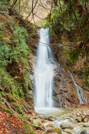
“The Odaki-Medaki waterfalls are a pair of falls on the way to Tsumago-juku. Rocks split the waterfalls into two sections, with the larger one known as Ogaki (Male Waterfall) and the smaller, gentler one known as Medaki (Female Waterfall). It was here that legendary samurai Musashi and his lover, Otsu, developed their relationship in Eiji Yoshikawa’s novel, ‘Musashi Miyamoto’ “
15th January 2023 – Tsumago
“Heading out of Magome, the highway led me towards the Magome-toge (Pass). I travelled beside the main road for a while, weaving in and out of woodland, past an old water wheel turning, generating power from the flowing water.
As I trekked through open fields, the air was clean and crisp, the sky a deep blue and the autumn colours ever-present. The Kiso Valley lay before me, inviting, verdant and filled with cypress trees. Luckily, due to Tokugawa’s foresight, tight controls on deforestation were introduced and a keen interest in forest conservation saved the valley from timber depletion.
I passed by the small village of Toge with its Edo era ambience and soon found myself on the Magome pass, meandering through woodland on a narrow path. To my surprise, a little distance in was a bell attached to a pole with a long chain and a sign saying ‘ring the bell hard against bear’. A bit of an eye-popping moment, I hadn’t realised the woods were frequented by Asiatic black bears. Although their presence is controlled, I sure didn’t want to be confronted by one, so with a hearty swing, I rang the bell loud and clear.
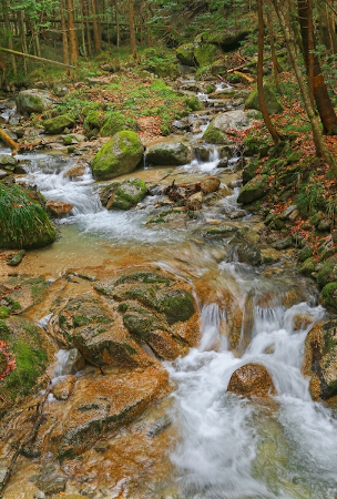
Once through the pass, I arrived at a small teahouse. A lovely rest stop that once used to be an inspection post monitoring travellers and the goods passing through. Back in the woods, I enjoyed the silence of the forest and the musical sound of the spring flowing, trickling over rocks. About 3mi (5km) later, I came across the Odaki-Medaki Waterfalls, two waterfalls near each other that translate as Male-Female Falls.
I passed through another small village then began the final descent through woodlands, beside gurgling streams and into Tsumago-juku (#42), now part of Nagiso. A little more rustic than Magome, the road is wider and the town is charming. As a post-town Tsumago was quite small and of no particular note, mostly due to its remote location. Today though, it is a major tourist destination with most of the buildings restored and all power lines underground, preserving the feel of the Edo period. Even the mailman is dressed in a traditional Edo era costume.”
15th January 2023 – Atera Valley local spot
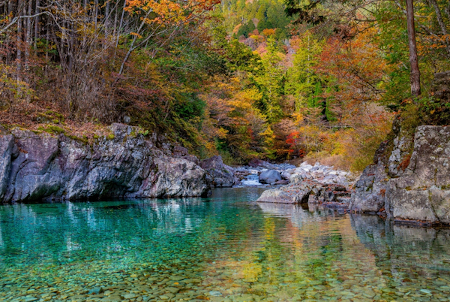
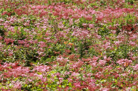
“The Atera Valley is a picturesque 4mi (6km) gorge, known for it’s emerald green water and numerous waterfalls. The color of the water comes from the rocks that line the river bed. The valley is also known for it’s beautiful flowers: rhododendrons, azaleas, clove cherry and coptis. The two temples in the area date back to the 14th century.”
By 15th January I had completed more than 40% of the challenge in only 20% of the allotted time.
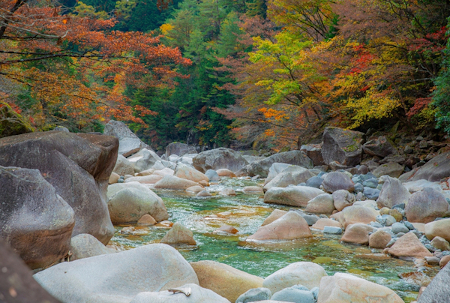
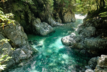
17th January 2023 – Nezame-no-toko Gorge
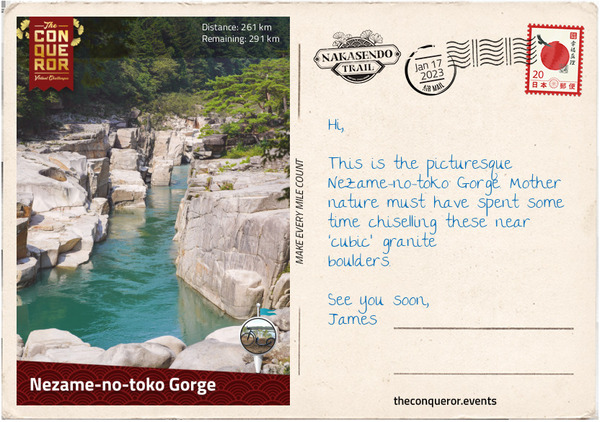
“Leaving Tsumago, I passed the site of an old castle with spectacular views of the valley. The trail narrowed as it re-joined the Kiso River.
The next post-town was the once prosperous Midono-juku (#41), now part of Nagiso. It has a fabulous wooden bridge, the Momosuke-bashi, that was built for small trolleys in 1922. Today it is a footbridge with views of the town and the Kiso River. In 1881, a huge fire destroyed the town. It was rebuilt around a railway station and its location moved. The few buildings left behind represent the various eras between the late 16th and early 20th centuries, along with remnants of an electric station from the early 1900s.
From Nagiso to Agematsu, the old highway is superseded by a modern one. Here the valley becomes very narrow and the highway, rail line and river compete for space. The trek is noisy until a few miles before the post-town of Nojiri-juku (#40), where it veers off into a quieter area for a short while and then re-joins the highway to Suhara-juku (#39). Both Nojiri and Suhara are now part of Okuwa.
Suhara was a lovely town to explore given its close proximity to the railway station. Many Edo period buildings survived, along with a joyato (stone lantern). Some of the buildings still had wooden water troughs at the front that in the past were provided for travellers. A specialty of Suhara is hanazuke, tea pickled with salt and cherry blossoms. Behind the village is Mt Komatagate, a popular hiking location and from the summit one can see Mount Fuji in the distance.
Five miles (8km) after Suhara, the Nakasendo veers from the modern highway, regaining the peacefulness of the old road. Just before I arrived in Agematsu (#38), I made a brief stop at Nezame-no-toko Gorge, a picturesque gorge with granite formations.
During the Edo era, Agematsu had an office for timber control where woodcutters would need to register. Strict rules were in place and tree felling without license was severely punished. When the trees were felled, they were loaded on rafts and floated downriver to Nagoya. Today, the timber from the Kiso Valley is still highly prized with several furniture factories and cabinet makers located in town.”
17th January 2023 – Senjojiki Cirque local spot
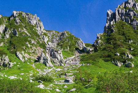
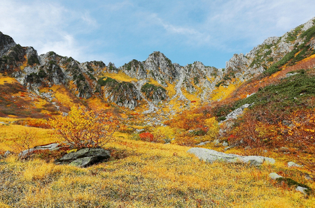
“Senjojiki Cirque is a cirque (glacial landform) that lies in the Kiso mountains in Komagane. The name ‘Senjojiki’ means ‘wideness of 1000 tatami mats’. There is a cable car service allowing tourists to easily access the cirque. In the winter it is a terrific location for skiing whilst in summer the cirque is filled with alpine flowers such as Anemone narcissiflora and Geum pentapetalum. A total of 128 plant species have been confirmed in the area.”
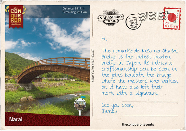
19th January 2023 – Narai
“As I move through the Kiso district, I pass through three post-towns: Fukushima-juku (#37), Miyanokoshi-juku (#36) and Yabuhara-juku (#35).
Fukushima was a major post-town and a checkpoint location. Being nearly halfway between Edo and Kyoto, it was a strategic place for keeping an eye on traffic and preventing the illegal movement of people. Regardless of societal position, each traveller had to wait their turn to obtain permission to pass through. Fukushima had a lively trading centre with all sorts of items for sale. The community leaders were very wealthy. A horse market took place annually with cotton and hemp goods, salted fish and rock mushrooms amongst some of the items sold. Today, it continues to be a prosperous town. It’s highly touristic with hikers or anglers coming in the summer and skiers in the winter.
The Kiso River cuts through the middle of Miyanokoshi and when it reaches Yabuhara it takes a westward direction whilst the route heads east. Miyanokoshi is the birthplace of the legendary Tomoe Gozen, an accomplished female samurai and mistress to General Kiso Yoshinaka, a member of the Minamoto clan. Tomoe fought alongside Yoshinaka in the 1180 AD Genpai War, toppling the opposing Taira clan. A few years later, Yoshinaka attempted to take control of the Minamoto clan from his cousin but failed. Knowing that he would be killed, he sent Tomoe away as he perceived his death beside a woman as shameful. Tomoe left but not before she beheaded a few more enemy warriors on her way out. What happened to her afterwards remains a mystery but her exploits on the battlefield are recorded in detail.
Beside a handful of antique shops from the Edo period, not much remains in Yabuhara. I pressed on through quiet countryside and into Narai-juku (#34), the first of five post-towns now part of Shiojiri district.
Narai has been beautifully preserved and although most of the buildings are barely a century old, they were built using traditional architecture. A very popular tourist destination there are many gift shops but in the centre of town are three former inns that continue to operate. Nearby is Nakamura’s Residence, a building from the 1830s that used to be the home of a lacquer comb trader. An important cultural property, today it is a museum exhibiting the interior of the house and lacquer combs.
About halfway through town is the beautiful 300 year old Kiso Bridge. Made of hinoki cypress, it is one of the largest arched bridges in Japan built without piers. The masterful timberwork can be appreciated at close range whilst the Narai River quietly flows beneath the bridge.”
19th January 2023 – Matsumoto Castle local spot
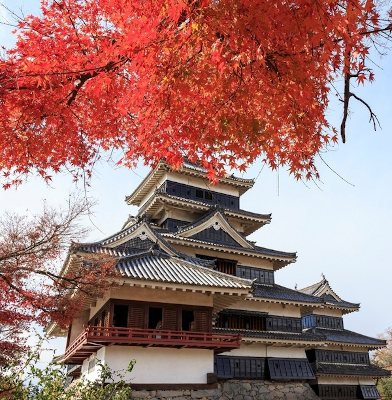
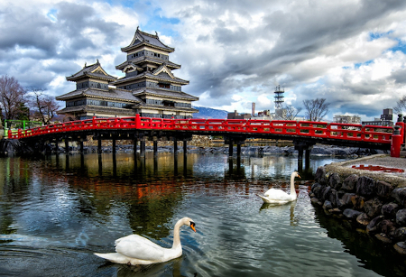
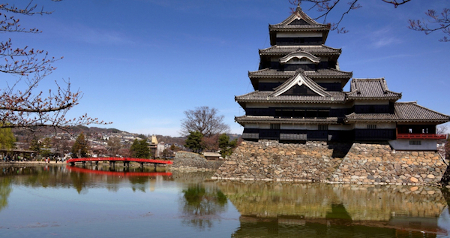
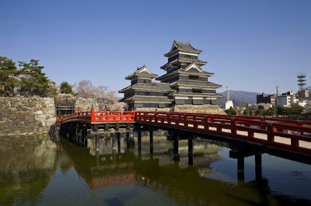
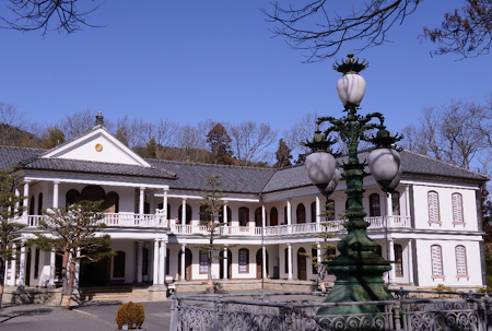
“Matsumoto Castle is a wooden and stone structure, built in the 16th century. It was used as a military fort for 364 years until the Meiji restoration in 1868. The Meiji government ordered it’s destruction and it’s outer walls were demolished. Following a campaign by the local people, the castle was saved and later renovated as the keep had a heavy lean. Today the castle is designated a National Treasure of Japan.”
On 22nd January, I had completed 60% of the challenge.
22nd January 2023 – Shimosuwa
“Not far from Narai is the small village of Harasawi, renowned for its lacquerware production. In the past, locals used to make utensils and bento boxes out of wood. Now, a finished product will have 6-18 layers of lacquer that requires 8-20 hours of drying time in a humid environment. The Kiso area is famous for the deep brown tone of its dishes. The lacquer comes from the sap of lacquer trees. Today, there are few surviving craftspeople but their work is nationally recognised.
Five miles on (8km), I trekked through a narrow stretch of the valley and arrived at Niekawa-juku (#33), once a border town between two domains (clan estates) with a checkpoint that was destroyed in 1869. The town, although small, had a large number of inns. At 6pm each evening, the highway would be closed to traffic, forcing travellers to stay the night in town. A fire in the 1930s wrecked the rest of the town. A 1970s reproduction of the checkpoint is all that is left of the era.
The next post-town was Motoyama-juku (#32) and its main industry was timber that was transported all the way to Edo. The Tokugawa shogunate maintained strict controls over the planting and felling of trees. Nothing remains of the post-town, having been destroyed by fire in the 19th century. Today, grapes have replaced the timber industry and it has important vineyards in the area.
The valley continues to be narrow and the old Nakasendo road is overlayed by the modern highway. The trail is rather noisy until I reach Seba-juku (#31). It used to be a weighing station, ensuring that cargo carried by porters did not exceed 85 pounds (38kg) – a regulation set by the Tokugawa shogunate.
Re-joining the modern highway, I passed through Shiojiri-juku (#30), a former post-town that served as a centre for salt production. Today, Shiojiri is a city with all the above-mentioned post-towns within its borders.
Exiting Shiojiri, the old road ran parallel to the main highway and began an upward climb to Shiojiri-toge (Pass). The roadside pine trees continued to provide shelter as they did during the Edo era when they were planted to protect travellers from the summer heat or winter cold.
The Shiojiri-toge was located at 3340ft (1018m) and it provided fabulous views of Lake Suwa, the town below and on a clear day, in the distance, Mount Fuji. The downhill trek through the woods was rather steep until I passed a few rice fields and entered the quiet and verdant town of Shimosuwa. During the Edo period, Shimosuwa-shuku (#29) was one of the earliest post-towns to be established. It was quite prosperous due to its location between two difficult mountain passes, Shiojiri-toge and Wada-toge, and its many hot springs. The passes are still there of course but the hot springs are now long gone.”
24th January 2023 – Tateshina
“Heading north of Shimosuwa, I entered the highest, most difficult and most dangerous pass, the Wada-toge. The climb up was rocky and very steep, reaching the summit at 5300ft (1615m). During the Edo period, riding travellers had to dismount and remove their baggage as it was too steep for horses to carry a load. In the winter, special clothing was worn by porters with straw boots woven in a particular way that kept their feet warm even when the boots were wet. Sometimes metal spikes were attached to the boots to grip the path. Alternatively, they would make boots out of wisteria and attach thorns beneath for grip.
Once over the pass, the descent took me into Wada-shuku (#28), now part of Nagawa. Wada is a popular spot for winter sports but in the past it was an important resting point for travellers prior to tackling the Wada-toge. It had 30 inns altogether, however a fire in 1861 destroyed all the buildings. A few inns that were rebuilt soon after the fire are still intact.
Continuing my descent, I travelled through a wide valley filled with rice fields. Many of the farms here had thatched [buildings], rarely seen in Japan nowadays. After five miles (8km), I reached Nagakubo-shuku (#27), another necessary resting point as it was located between Wada-toge and the next pass, Kasadori-toge.
The next post-town was Ashida-shuku (#26), now Tateshina, which was described as a “shabby looking village”. It continues to have the “shabby” image except for the well-preserved honjin that claims to be the oldest on the highway and the location where Princess Kazu (postcard 8) rested for the night. The inn is classified as a National Treasure now.
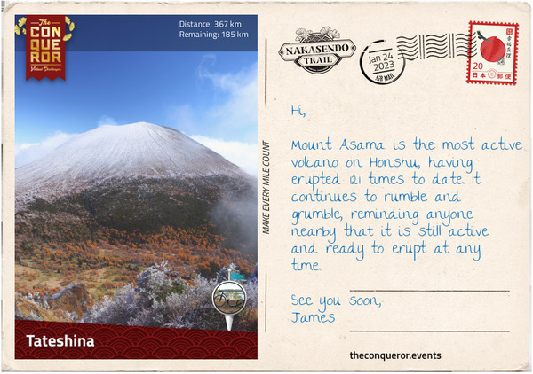
Travelling towards Mochizuki, I got my first view of Mt Asama, a volcanic mountain that in 1783 erupted over a period of 15 hours with lasting effects that carried on for the next three months. The arable land in the area was already in poor condition because of cold weather but after the eruption the land became fallow for several years. These events led to the Great Tenmei famine that lasted for five years. Mt Asama continues to rumble and threaten with earthquakes and it is said that the mountain often wears a “benign plume of smoke”, as if to warn that it is always ready for another eruption.
I am happy to admire it from a distance and mentally wish that it keeps itself in check whilst I am passing through.”
26th January 2023 – Usui Bridge
“At the base of Mt Tateshina is the former post-town Mochizuki-shuku (#25). Together with Yawata-shuku (#24), Shionada-shuku (#23) and Iwamurada-shuku (#22), the town was absorbed into the city of Saku.
Mochizuki was known for horse breeding and supplying them to the Imperial Court. The post-town remained small and even though it had business passing through, it went into a slow decline.
Yawata and Shionada were only 500m apart, separated by the Shinano River, the longest and widest river in Japan. They were connected by a pontoon bridge until it was washed away by a flood and never rebuilt. Instead, ferry services were introduced and used to cross the river. Yawata remained a small post-town and was only used by travellers as a rest point when the river couldn’t be crossed. It also served as a distribution centre for rice.
Iwamurada was a castle town. It didn’t have any inns during the Edo era. The local daimyo rose to fame when he delayed the leader of the Western Army prior to the Battle of Sekigahara.
I moved through Otai-shuku (#21), now part of Miyota, to the city of Karuizawa and its former post-towns, Oiwake-shuku (#20), Kutsukake-shuku (#19) and Karuisawa-shuku (#18). As I get closer to Tokyo, I get the distinct feeling that many of the old post-towns have been taken over by big cities and modern life. Whilst there may be small remnants of Edo history, I will likely experience more and more modern aspects from here on. The flavour of this journey will shift from 17th century history to current times.
With that in mind I noted that Karuizawa, which nearly went into complete decline, was revitalised after WWII and became a summer resort location. It is visited by thousands of people who want to escape the hustle and bustle of Tokyo. Its local fame was sealed in the 1950s when former Emperor Heisei met his wife on a tennis court in Karuizawa and triggered a travel boom to the city.
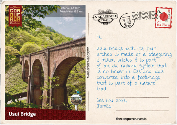
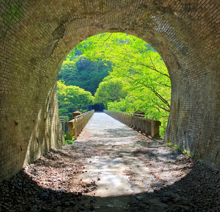
Outside of town, I started my trek uphill through the Usui-toge (Pass) and found myself walking through a tunnel for about a mile (1.6km) and exiting on Usui Bridge, an arched 17th century bridge. The tunnel was part of a former railway and the bridge is the largest arched brick bridge in Japan. Built in 1892, the bridge was used for 104 years until the railway line was closed and the bridge was converted into a footbridge.
During the Edo era, Usui Pass was a major checkpoint, ensuring that that the wives of the daimyos were not being smuggled out of Edo (they were kept as hostages as a way to keep the daimyos under control), that firearms were not being imported and that the peasants didn’t leave their clan’s territory.”
27th January 2023 – Usui Pass Railway Heritage Park local spot
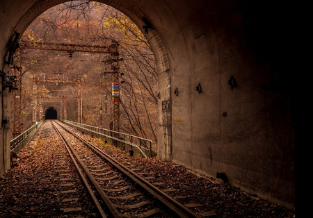
“The Usui Pass Railway Heritage Park is an open air railway museum. The Usui Pass was a transportation hub and initial plans for a railroad were abandoned because construction was too complex. The idea was revisited at a later stage and in 1893 the Yokokawa – Kariuzawa line opened. It travelled through 26 tunnels and over 18 brick bridges. When modern trains were introduced, the railway was closed and turned into a heritage park.”
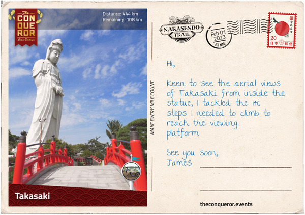
1st February 2023 – Takasaki
“After Usui Pass I made my way into the city of Annaka, which absorbed four former post-towns: Sakamoto-shuku (#17), Matsuida-shuku (#16), Annaka-shuku (#15) and Itahana-shuku (#14).
Matsuida was an important town as it handled the overflow of travellers when the traffic at Usui checkpoint was backed up with a queue. There used to be a side road in town that was less trafficked which was often used by those who wanted to bypass the checkpoint, making it a perfect smuggler’s lane.
Annaka used to be a castle town. The first castle was burnt down after five years and another was built by Tokugawa Ieyasu’s son. It later became the seat of the Itakuna clan. In 1855, one of the clan members asked his retainers to run up the hill to Usui Pass 18mi (28km) away. This instance was the inspiration for the Usui Pass Run 184, an annual half marathon racing event. The 184 is in reference to the number of turns taken as one ascends the course, gaining 400 metres in elevation.
Less than a mile (800m) from Annaka is Itahana. This was the shortest distance between post-towns. The old route crossed the Usui River twice, as such a teahouse was established in-between the two crossings, aptly named Nakajuku ‘resting place in the middle’. Itahana had a lively nightlife and was a place to escape to, away from the watchful eyes of shogunate officials.
Three miles (5km) further, I arrived in the city of Takasaki and its former post-towns Takasaki-shuku (#13), Kuragano-shuku (#12) and Shinmachi-shuku (#11). Takasaki is known for its Daruma doll, a hollow, round doll, usually painted red, depicting a bearded man. It is meant to symbolise good luck. The town is also known for the towering 138ft (42m) and 6,000 tonne statue of the Goddess of Mercy (Byakue Dai-Kannon). During the Edo period, Takasaki was a castle town and one of the largest towns on the Nakasendo. Given its size it had few inns, most likely because travellers did not want to stay close to the castle and the ruling daimyo.”
By 1st February I had compelted 80% of the chellenge.
2nd February 2023 – Kumagaya
“What a fascinating journey this has been so far. I have travelled through 59 post-towns and am down to the last ten. Let’s see what the next three towns (the post-towns have the same name) have to offer.
The highway travels beside the Motokoyama River which flows through Honjo-shuku (#10). During the Edo period, travellers would have to hire a boat to cross the river that was split by land. A local businessman decided to build a bridge that can be crossed by travellers free of charge in the hope that they would come to his shop. Unfortunately, he didn’t have enough funds to build across the entire river, so the travellers still needed to hire a boat for a fee to complete their journey across the whole river.
Coming into Fukaya-shuku (#9), the scene is peaceful with craftspeople sitting on tatami mats doing business over a cup of tea. However, in the Edo era it was a wild place, known for its red-light district and the fierce competition amongst the 80 inns. Fukaya was also a communication hub and the railway station built in 1887 in a Victorian style echoes the Western influence of the late 19th century.
For the next seven miles (11km), the Nakasendo crosses the modern highway many times, all the way into Kumagaya-shuku (#8). Some sections of the highway were lined with ginkgo trees instead of the usual pine trees.
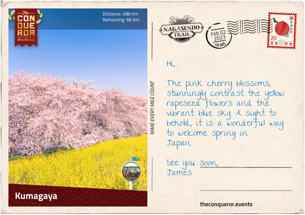
Kumagaya is located between Tone River in the north and Arakaway River in the south. In spring, the banks of the Arakawa River burst with colour as the pink cherry blossom trees and the bright yellow rapeseed flowers come into full bloom. Picnickers laden with food and sake flock to the area to celebrate the coming of spring.
In Kumagaya the go-to meal is udon noodles because the wheat used in the noodles is locally grown and rich in flavour. Another popular food is a dessert that originated in the Edo era known as gokabo. It is a sweetened rice cake roll coated in roasted soybean powder. It looks like I may need to find a place that serves both.”
By 3rd February I had ridden 500km on my Kickbike since the start of the year and had just 40km to complete the challenge.
5th February 2023 – Omiya
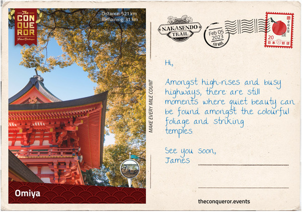
“The hustle and bustle of modern life and big cities was ever-present as I edged closer to Tokyo. The old post-towns are now just memories with few buildings left as reminders. I reached Saitama, a densely populated city with over a million residents that is part of the Greater Tokyo Area. Very little is left of the five former post-towns. Three have risen to city status whilst the other two became wards in Saitama. Each has retained their original name.
Konosu (#7) was destroyed in WWII, leaving only a stone marker at the location of the former honjin but due to its close proximity to Edo, it was a bustling post-town with 58 inns. However, even more bustling was Okegawa (#6) with 340 inns and numerous entertainment establishments. The nearby Kano Tenjin Shrine was known for its thermal baths that apparently cured several diseases.
Between Okegawa and Ageo (#5) were expansive fields of red flowers that would bloom in summer. Ageo was a flower trading town and the red flowers provided the necessary colour for the cosmetic rouge demanded by high society ladies and geishas.
Omiya (#4) and Urawa (#3) are now wards of Saitama. Omiya was a prosperous town with very comfortable honjins making it a preferred final stop for daimyos and their entourage prior to reaching Edo. Omiya draws its name from a large Shinto shrine that had the highway passing behind it. Regarded as disrespectful to the shrine both the highway and the town were moved in front of it encouraging travellers to visit and make offerings.
A mere two miles (3km) away was Urawa (#3). The old highway was lined with high-rise buildings and the constant noise of modern traffic was a reminder that I was nearing the end of my journey.”
5th February 2023 – Omiya Bonsai Village local spot
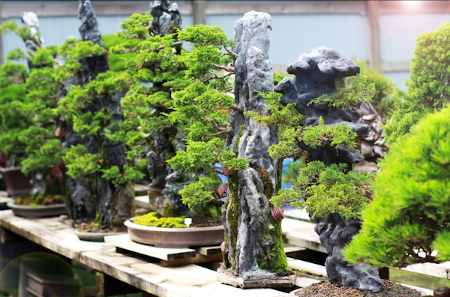
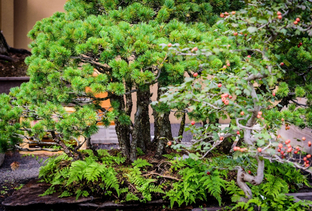
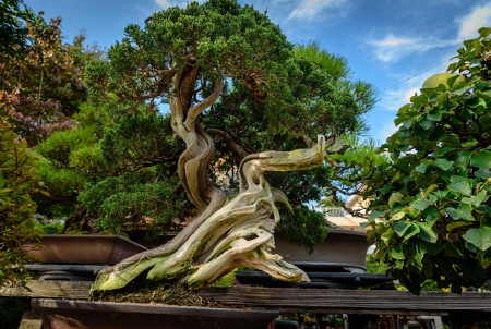
“Omiya Bonsai Village is the nickname for the Bonsai nursery precinct in Bonsai-cho. The village was established in the 1920s by a group of professionals who left Tokyo after a significant earthquake. Today, the village consists of 10 private bonsai gardens, a bonsai museum and the annual”Great Bonsai Festival” that is packed with bonsai devotees from all over Japan”
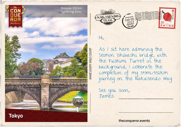
5th February 2023 – Nihonbashi Bridge local spot
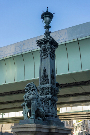
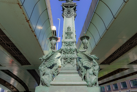
“The original Nihonbashi Bridge was built at the request of shogun Tokugawa Ieyasu in the early 1600s. At the time, all the distances to Tokyo were measured from one central location, making it the starting point for the five major roads and the center of Japan. The current twin arch stone bridge was built in 1911. The kirin statue in the center of the bridge depicts the prosperity of Tokyo and the lion statues on the four corners depict protection.”
5th February 2023 – Tokyo
“The final two post-towns, Warabi (#2) and Itabashi (#1) are now long distant memories. Nothing remains of the past except a watchtower and a bridge in Itabashi.
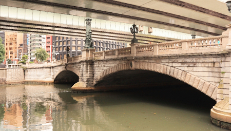
The Nakasendo terminates in Tokyo at Nihonbashi Bridge, “Bridge of Japan” and the heart of Edo where all Japanese roads began. When Tokugawa Ieyasu ordered the construction of the bridge, his intent was to make it the central point from which all distances were measured throughout the country. It essentially made the bridge ‘the nation’s cartological zero point’.
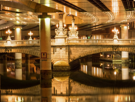
The wooden bridge was replaced in 1911 by a beautiful twin-arched stone bridge with candelabras, four lions at the corners and a kirin statue in the centre. During the 1960s, Japan built a massive expressway directly over Nihonbashi, hugely overshadowing this once highly significant and historical bridge. The views are now long gone but before the expressway, on a clear day, Mt Fuji could be seen from the bridge.
Instead of ending my journey at Nihonbashi, I headed to the Imperial Palace to explore. Located within a large park, the palace is home to the Emperor of Japan and built on the site of the old Edo Castle. At the end of the Edo period, the Tokugawa shogun at the time was requested to depart Edo Castle and the Emperor of the new Meiji period moved in. The current palace was built in the late 1880s after the previous one was destroyed by fire. The grounds, surrounded by a moat, are filled with gardens and quaint bridges, connecting the various residences and administrative offices.
Ending my journey with a meander, I reflect on the history of the Nakasendo, the powerful Tokugawa shogunate, the wonderful quiet wooded sections amongst the preserved old post-towns, the steep hills with stone paving and I imagine the massive journeys daimyos would undertake every other year going back and forth between Kyoto and Edo.”
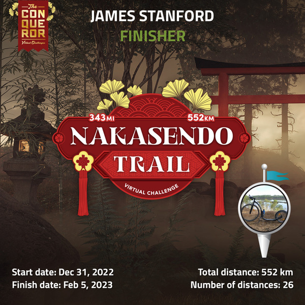
And that’s the finish of the challenge. I kickbiked 552km in 35 days, which was half the amount of days I set as the goal to complete the challenge.
You May Also Like
One Comment
Mum
WOW!! The scenery is magnificent, James. Well done on you kick-biking effort..